
COUPON CODE SUMMER24 GET 10% OFF
(Tempest is an affilllate of Meteorologist Joe Cioffi & earns commissions on sales.)
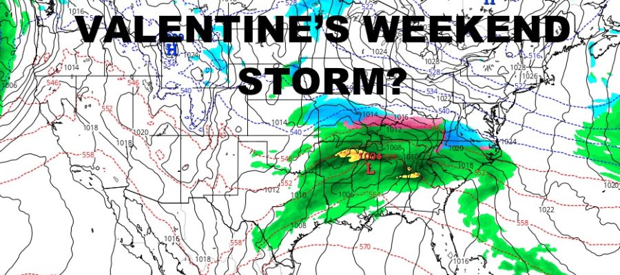
Large System May Be Lurking Around Valentine’s Day
Good morning everyone. Cold to extremely cold air remains locked into the Northeast and NYC Metro area. Things look to remain the same as a new reinforcing shot of bitter cold air swings through on Friday for your weekend. We’re also keeping an eye on indicators for a moisture-laden system lurking around the time of Valentine’s Day. As of now, the margin of error is +/- 2 days, but we will be watching it closely.
Now you may say, “Ben, that’s ridiculous, how do you know more than 10 days out?” Well, we don’t know what form the precipitation will be coming in or even if it makes it into the Northeast or not; but even before we get to the 10 day mark, things begin to brew in the 7-8 day range which is more than reasonable.
At minimum, the Gulf Coast and Southeast could see some heavy rain and severe weather with this one; so we’ll watch and see if it pans out/what it looks like. Check out your immediate forecast below….
SATELLITE

Sunshine returns today and it’ll feel “mild” as we approach the freezing mark for the day. However, the snowpack will still play a role, helped along with lights winds and relatively clear skies. Temps will once again dip into the low to mid teens.
WEATHER RADAR

Thursday looks more of the same, then we’ll be watching that reinforcing shot of cold air. look for increasing clouds Friday, highs in the upper 20’s to near 30. Lows drop into the teens again, but we could see a band of snow moving through as that frigid air sweeps in. For those who do see some snow showers, we could see a coating – 2″ depending on where the more squally-type cells transit.

Regardless, the bottom drops out on Saturday with highs in the upper teens to low 20’s. Low temps overnight will be dangerously low in the 0-5 range. Highs Sunday will be 15-20, then single digits again overnight.
BE SURE TO DOWNLOAD THE FREE METEOROLOGIST JOE CIOFFI WEATHER APP &
ANGRY BEN’S FREE WEATHER APP “THE ANGRY WEATHERMAN!
MANY THANKS TO TROPICAL TIDBITS FOR THE USE OF MAPS
Please note that with regards to any severe weather, tropical storms, or hurricanes, should a storm be threatening, please consult your local National Weather Service office or your local government officials about what action you should be taking to protect life and property.