
Latest Weather Update Sunday March 29, 2026 10:48am
NYC Mild Air Arrives Early Leaves Early
Good morning everyone. After a seasonably cool and breezy day today, milder air makes an early showing and early exit. Initially, we thought the warm front would struggle tomorrow through Wednesday, then finally busting through Thursday. Instead, the warm front makes it through, with our cold front sweeping by late Wednesday. This will make for a cool end of the week and part of next weekend before the next front sweeps through.
We are watching a very fast pattern, but typical for this time of year as most of our systems are beginning to take a more northwesterly track well-west of us and into the Great Lakes.
SATELLITE

For today, it’ll be a breezy one and seasonably cool. Current temps in the low 40’s will rise into the mid 50’s by midday.
WEATHER RADAR

To start your workweek, we’ll have a mix of sun & clouds and a slight chance of widely scattered showers. Depending on how much sun we get, mid 60’s are not out of the question. Tuesday we go right into very mild-mode with another mix of sun & clouds, slight chance of a shower, and muggy mid to upper 70’s.
We peak out on Wednesday with highs near 80º, cooler at the shore, and morning sun giving way to late afternoon clouds. We”l have the chance of some evening rain, possibly heavy at times with a rumble or two possible.
Clouds stick around Thursday, Friday, and Saturday, with the chance of some showery conditions and highs in the mid to upper 50’s. For Sunday, we play the warm front game to see if it can transit the area or not. Highs could be in the 50’s, or the near 80º range depending on what that warm front wants to do.
BE SURE TO DOWNLOAD THE FREE METEOROLOGIST JOE CIOFFI WEATHER APP &
ANGRY BEN’S FREE WEATHER APP “THE ANGRY WEATHERMAN!
MANY THANKS TO TROPICAL TIDBITS FOR THE USE OF MAPS
Please note that with regards to any severe weather, tropical storms, or hurricanes, should a storm be threatening, please consult your local National Weather Service office or your local government officials about what action you should be taking to protect life and property.
ADDITIONAL WEATHER INFORMATION
RAIN & SNOW FORECAST MAPS
NEW YORK CITY AND VICINITY RAIN FORECAST
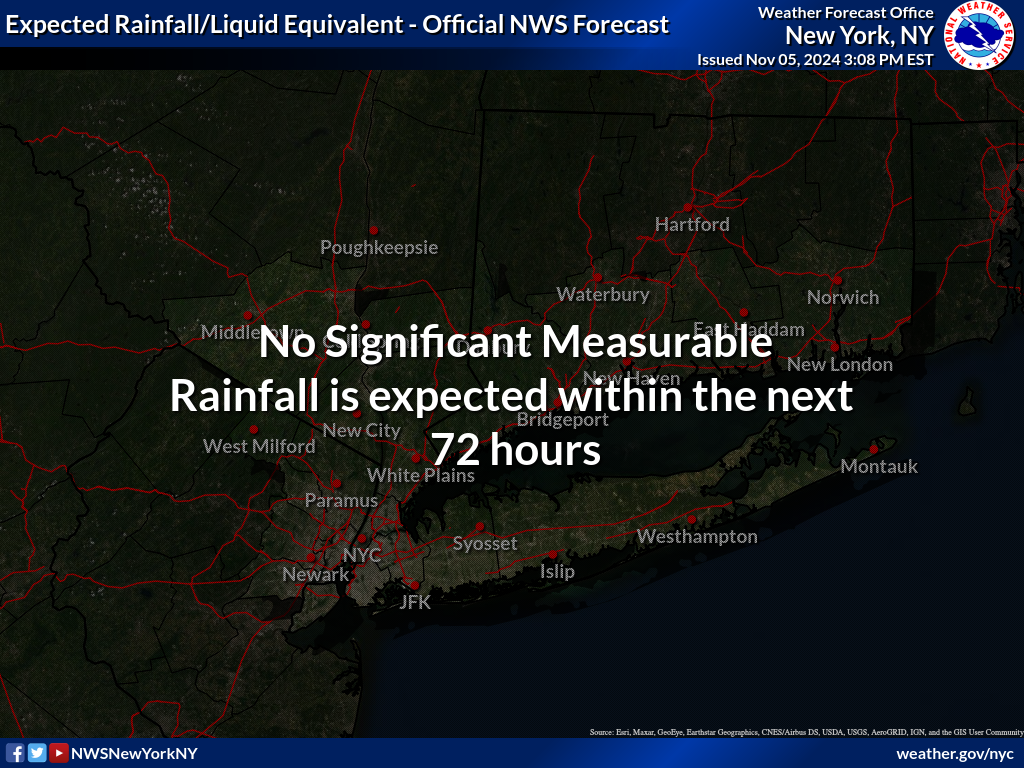
New York City, Ne NJ, HV, LI, Coastal Ct
SOUTHEAST NEW ENGLAND
NEW JERSEY & PARTS OF NE PA

SATELLITE LOOP

LOCAL RADAR NEW YORK CITY

RAINFALL FORECAST
A
MANY THANKS TO TROPICAL TIDBITS FOR THE USE OF MAPS
Please note that with regards to any tropical storms or hurricanes, should a storm be threatening, please consult your local National Weather Service office or your local government officials about what action you should be taking to protect life and property.