DOWNLOAD MY NEW FREE JOESTRADAMUS WEATHER APP FOR ALL DEVICES
More NYC Gloom Today Spring Weekend Possible
Good morning everyone. Yesterday’s rain didn’t catch us off-guard, but the colder than expected temps did. Unfortunately for us today, we’ll have somewhat of a repeat from yesterday. There is some good news, maybe, in all of this; in the form a possibly nice weekend brewing, but we have to keep a close eye on it all.
EASTERN SATELLITE

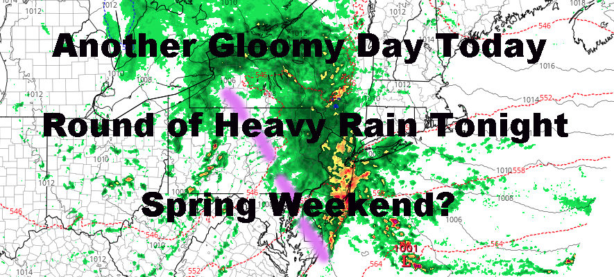
We’re catching a brief break today if that’s what you want to call it. In between raindrops, we’ll have cloudy skies and drizzly conditions. We’ll get another round of rain within the next few hours, then maybe another break, then the big stuff moves in for the evening/overnight. Highs today will feel like the winter we just had, with unseasonably cold temps in the upper 40’s if we’re lucky.
When our fairly vigorous wave passes by tonight, we could see a few rumbles of thunder even though most outlets aren’t discussing it. I see enough convective energy potential there for it, but at minimum, we should see some hefty rain, even if it doesn’t come with thunder. When this wave pushes through, there will also be enough evaporative cooling in the higher elevations in upstate NY, VT, NH, MA, ME, and maybe even parts of CT to drop some snow again like yesterday. It’s rare this time of year, but not unheard of in these spots/elevations.
Along the immediate shores, coastal flooding is possible due to the extended easterly fetch. Look for minor to moderate coastal flooding issues during times of high tide and in areas prone during prolonged conditions like this. We’re not looking at anything near hurricane or severe nor’easter-type flooding, but there could be nuisance flooding at or near bulkheads.
REGIONAL RADAR

We slowly start to recover tomorrow. Very slowly. Cloudy skies will remain, but the rain potential will start to diminish. We’ll also begin to slowly rise out of the basement temp-wise with highs in the low to mid 50’s. Overnight tomorrow, clouds will begin to break up and a northwesterly flow will begin to set us up for a decent but seasonably cool Wednesday.
We’ll be sandwiched in between two systems for Wednesday, so hopefully we see a period of full sunshine before the clouds return some time between late afternoon and late evening. At least we’ll be dry and highs recover into the mid 60’s.
LOCAL RADAR NEW YORK CITY

After some mid-week sun, weak energy returns in the form of a fast-moving system and a warm front. This will bring the chance of maybe a few showers Thursday morning, and a few showers some time on Friday. In between, we’ll be in and out of sun both days with highs 65-70 depending on how much sun we get. We could poke a little higher if the sun cooperates.
Next weekend remains questionable as a more traditional May-like system begins to approach from the west. The big question will be that warm front on Friday and how far north it goes. If it goes well north of us, we could get a taste of deep spring/early summer this weekend. If it drags its butt along and drapes over us, well, you know how that story goes.
I’ll be keeping a close eye on this and pin it down as we get closer. The potential is there, but don’t get excited yet. I won’t discuss temps, because we could wind up in the 60’s, or we could wind up in the 80’s…or somewhere in between.
LOCAL RADAR PHILADELPHIA


In the long range, an active pattern continues, with systems continuing to march into the west coast, then quickly come our way. The question is, are we slowly pulling out of the funk? will systems begin moving well to our north again and clearing out?
Either way, it looks like a wet pattern remains for the next couple of weeks. It’s just a question of whether we are warm and wet, or raw and damp.
MANY THANKS TO TROPICAL TIDBITS FOR THE USE OF MAPS
Please note that with regards to any tropical storms or hurricanes, should a storm be threatening, please consult your local National Weather Service office or your local government officials about what action you should be taking to protect life and property.