
COUPON CODE SUMMER24 GET 10% OFF
(Tempest is an affilllate of Meteorologist Joe Cioffi & earns commissions on sales.)
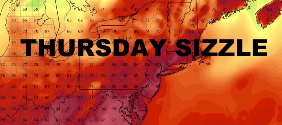
NYC Thursday Sizzler Arrives
Good morning everyone. Our second day of hot weather will be the last as “cooler” conditions head it tomorrow. Mid 90’s will give way to mid 80’s tomorrow, then we have a juicy weekend ahead with some thunderstorms on the back end. Comfortably warm temps start the workweek next week.
SATELLITE

Today is the hottest day of the stretch, with mid 90’s likely and the slight chance of a PM storm. Near 100 temps are possible just to the west of Manhattan and interior parts of Brooklyn and Queens.
WEATHER RADAR

We cool down a bit on Friday with full sunshine and highs in the mid to upper 80’s. Look for a repeat on Saturday with the chance of a few PM storms. Sunday is looking stormy with humid mid to upper 80’s. On and off showers and storms will plague the region. Localized flooding will be possible.

Those showers and storms bring a comfortably warm day on Monday, with full sunshine and highs in the mid 80’s.
BE SURE TO DOWNLOAD THE FREE METEOROLOGIST JOE CIOFFI WEATHER APP &
ANGRY BEN’S FREE WEATHER APP “THE ANGRY WEATHERMAN!
MANY THANKS TO TROPICAL TIDBITS FOR THE USE OF MAPS
Please note that with regards to any severe weather, tropical storms, or hurricanes, should a storm be threatening, please consult your local National Weather Service office or your local government officials about what action you should be taking to protect life and property.