
COUPON CODE SUMMER24 GET 10% OFF
(Tempest is an affilllate of Meteorologist Joe Cioffi & earns commissions on sales.)
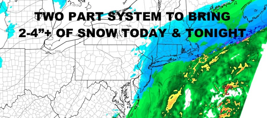
NYC Two Rounds of Accumulating Snow Today & Tonight
Good snowy morning everyone. Light to moderate snow is falling across the NYC Metro area for the first round of a two-part system. We’re not expecting anything crazy accumulation-wise, but we are slowly inching towards the seasonal average as a cold and somewhat active winter continues.
SATELLITE

Look for snow tapering off with some dry air pushing in, then snow redeveloping later today and lasting until before midnight. Total accumulations between now and tonight should be in the 2-4″ range, but we could see a few 5″ amounts scattered about. Highs may sneak up into the mid 30’s when the snow takes a break, then fall again as precipitation becomes more steady again.
WEATHER RADAR

Tomorrow is looking cold with highs in the upper 20’s to low 30’s. Expect brutal overnight conditions with gusty winds and lows in the low to mid teens. Tuesday doesn’t look much better as winds continue and high are stuck in the low 20’s at best. Things will improve on Wednesday with highs climbing back up into the low 30’s; then mid to upper 30’s by Thursday.

We’ll watch the same pattern replay itself with another shot of cold air sweeping through on Friday/Staurday; and eyes turn to see if there’s any “rebound” waves coming up or brushing the coast with some snow or mixed precipitation.
BE SURE TO DOWNLOAD THE FREE METEOROLOGIST JOE CIOFFI WEATHER APP &
ANGRY BEN’S FREE WEATHER APP “THE ANGRY WEATHERMAN!
MANY THANKS TO TROPICAL TIDBITS FOR THE USE OF MAPS
Please note that with regards to any severe weather, tropical storms, or hurricanes, should a storm be threatening, please consult your local National Weather Service office or your local government officials about what action you should be taking to protect life and property.