
COUPON CODE SUMMER24 GET 10% OFF
(Tempest is an affilllate of Meteorologist Joe Cioffi & earns commissions on sales.)
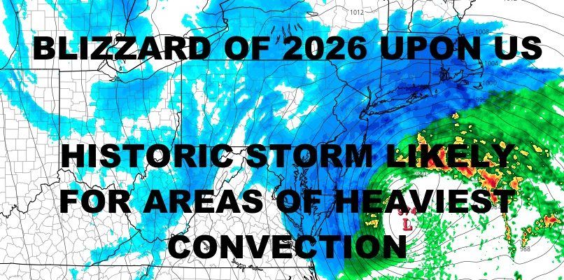
Blockbuster Nor’Easter With Blizzard Conditions Begins Today
Good morning everyone. Our system is beginning to take shape in the region, with light rain, snow, and mixed precipitation breaking out across the City and Long Island. Any rain or mixed precipitation will turn to all snow by early to mid-afternoon, intensify, and begin to stick on sidewalks and streets.
SATELLITE

Intensification of snow rates will likely begin some time between late afternoon and early evening for NYC and Long Island. In terms of the “big stuff” when it comes to heavy snow and increasing winds, look for that to step-up some time between 9pm and midnight. Heavy snow, blowing snow, and possibly thundersnow, will continue into the morning hours. On and off light, moderate, and heavy snow should grace the region into the early to late afternoon from west to east.
WEATHER RADAR

Temps will plummet into the upper teens to low 20’s overnight Monday with the help of very cold air pouring in behind the system, plus snowpack blanketing the area. For Wednesday, we could see another round of snow changing to rain; which will cause issues with ponding and flooding due to poor/no drainage.

Overall, snow totals look steady in my mind and I’m keeping things conservative due to the speed of the system. Look for a wide swath of 12-18″+ of snow up and down the I95 corridor. Where the heaviest convective bands set up, we could see 18-24″+ of snow. Some maps show 30″+ possible in spots, but realistically we have to wait and see what the radar looks like and if any dry slots occur. With storms such as this, we could see big variations just miles away from locales which got the average amount.
Winds in excess of 45-60mph, especially at the coast, will produce blowing and drifting snow. Welcome to The Blizzard of 2026 folks! Stay safe!
BE SURE TO DOWNLOAD THE FREE METEOROLOGIST JOE CIOFFI WEATHER APP &
ANGRY BEN’S FREE WEATHER APP “THE ANGRY WEATHERMAN!
MANY THANKS TO TROPICAL TIDBITS FOR THE USE OF MAPS
Please note that with regards to any severe weather, tropical storms, or hurricanes, should a storm be threatening, please consult your local National Weather Service office or your local government officials about what action you should be taking to protect life and property.