
COUPON CODE SUMMER24 GET 10% OFF
(Tempest is an affillate of Meteorologist Joe Cioffi & earns commissions on sales.)
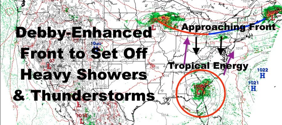
Debby-Enhanced Front Brings NYC Severe Weather Risk
08/05/24 11:33am ET
Good late morning everyone. We have a hot and muggy day in much of the Northeast & Mid-Atlantic as “dead air” sandwiched in between Hurricane Debby and an approaching front heats up very fast under full sunshine. That front will be a big player over the next few days as it first bumps into tropical energy surging north tomorrow, then helps steer Debby’s moisture up or near the coast.
For tomorrow, the severe weather risk looks to be mostly north and west of the New York City area and in interior parts of the Northeast. However, that front will eventually sink down far enough, where we could see some heavier action in the NYC and Long Island area Tuesday night into Wednesday. The Greatest risk for severe weather overall, will be central and eastern Pennsylvania, northwest New Jersey, and upstate New York.
The biggest risk with our severe weather will be large hail, gusty winds, frequent lightning, and torrential rain. As that front taps more of Debby’s energy, look for an increase in tornado risk as well.
Meanwhile, catastrophic rain flooding is expected across north Florida, central and southeast Georgia, and the South Carolina coastal plain. Hurricane Debby has no been downgraded to a tropical storm, with winds at 70mph and NNE at a turtle-like 8mph. This is going to be the trend and the problem as far as slow movement and torrential rain. Three to Four days of heavy rain is expected, with 15-20″+ of rain likely in areas that cannot handle it due to very old infrastructure.
Areas such as Charleston, Savannah, and Myrtle Beach, are all in line for historic rainfall and flooding over the course of the next few days. Please stay tuned to your local agencies for the latest watches and warnings. Do not attempt to cross deep and/or fast moving water in your vehicles or on foot. Evacuate if told to do so.
Here is your local NYC Metro Forecast –
SATELLITE

Look for sunny skies, hot, and muggy conditions today with highs 90-95 in most spots. Clouds begin to increase tonight with lows only getting down into the mid to upper 70’s. We’ll have mostly cloudy skies tomorrow, muggy conditions, and the chance of PM heavy showers and storms.
WEATHER RADAR

The same goes for Wednesday, but we are much cooler in the mid 70’s. It won’t feel cool though as muggy tropical air takes hold. Look for more heavy rain and rumbles both Thursday and Friday, with more muggy mid 70’s.

Saturday looks more of the same, and it doesn’t look like we begin to clear things out until Sunday. Expect decreasing clouds, drier conditions, and highs a comfortable low to mid 80’s.
BE SURE TO DOWNLOAD THE FREE METEOROLOGIST JOE CIOFFI WEATHER APP &
ANGRY BEN’S FREE WEATHER APP “THE ANGRY WEATHERMAN!
MANY THANKS TO TROPICAL TIDBITS FOR THE USE OF MAPS
Please note that with regards to any severe weather, tropical storms, or hurricanes, should a storm be threatening, please consult your local National Weather Service office or your local government officials about what action you should be taking to protect life and property.