FIRST NYC AUTUMN NOREASTER BRINGS TYPICAL CONDITIONS
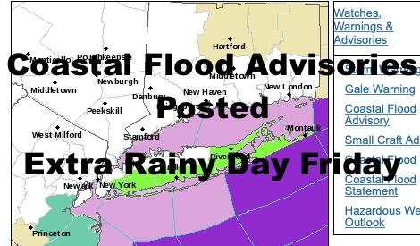
Good morning everyone. Our first Nor’easter of the season is upon us, and it’s doing its thing as far as Nor’easters go. The map is lighting up with watches and warnings, and as expected, the immediate coast will be the area primarily affected by the wind; and obviously the prospect of coastal flooding. The only slight curveball here will be the potential for an extra day of rain on Friday as this system is slow to pull away.
SATELLITE

For today, expect rainy and breezy conditions as rain retrogrades from east to west across Long Island and into he NYC area. None of this will result in an all day washout, but look for on and off periods of rain and highs a raw near 60. Steady NE winds 15-20 will be felt throughout the area, with a slight uptick at the immediate shore and slightly higher gusts.
REGIONAL RADAR

Rain will cut off tonight and the wind will increase as our Nor’easter begins to spool up and interact with high pressure to our north. We’ll have another chance of on and off rain tomorrow, and winds will peak between tomorrow and tomorrow night. It’ll also be the best chance for nuisance coastal flooding with low pressure essentially stationary and piling water up. For those who live in areas that see flooding during Nor’easters, make sure you take action to protect property; specifically by moving your cars away from areas that easily flood, and make sure your sump pumps are operational if you get water in your basement easily. Highs tomorrow will also be a raw near 60, and wind gusts may reach 40+ mph at the immediate shores, with the Forks of Long Island going 50-55+ mph possibly.
LOCAL RADAR NEW YORK CITY

Things will be slow to pull out on Friday, so expect the wind gusts to continue, as well as the chance of showery conditions and highs near 60 again. We could also have 2 more tide cycles above normal, so continue to be vigilant if you live in low lying areas that flood easily and often.
We’ll finally begin to clear everything out on Saturday, but it’ll be a slow process. Look for the slight chance of a morning shower, then partial clearing and highs in the mid to upper 60’s (sunshine dependent). Sunday we start out with more clouds than sun, then mostly sunny skies late; highs in the mid to upper 60’s.
Columbus Day will be a treat, with full sunshine, seasonal temps, and an overall pleasant day.
LOCAL RADAR PHILADELPHIA


MANY THANKS TO TROPICAL TIDBITS FOR THE USE OF MAPS
Please note that with regards to any tropical storms or hurricanes, should a storm be threatening, please consult your local National Weather Service office or your local government officials about what action you should be taking to protect life and property.