HURRICANE FLORENCE EAST COAST QUESTIONS REMAIN
Good morning everyone. While today was supposed to be a big day in terms of getting a better idea of where Hurricane Florence may strike, things slowed down a bit yesterday speed-wise and strengthening-wise. This creates more questions and adds to the nuances of our forecast, but also gives people an extra 12-24 hours to prepare if it looks as if their area may be the focus.
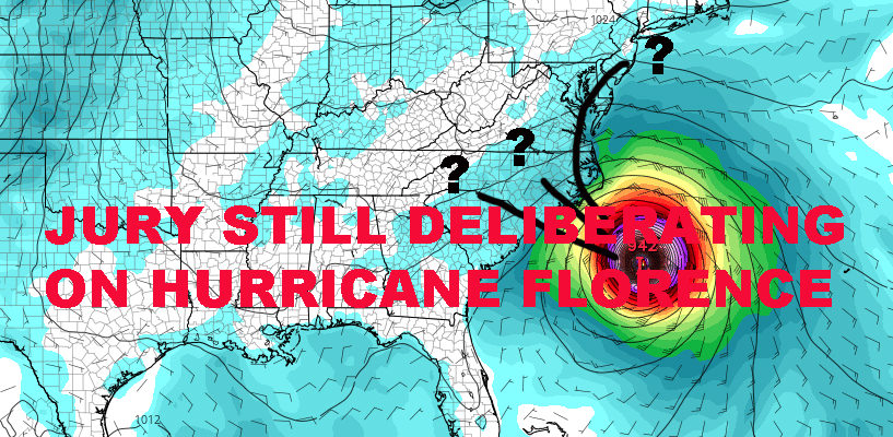
As stated yesterday, I refuse to tell anyone at this point that they can breathe a sigh of relief. There are too many uncertainties in the forecast, specifically for the mid-Atlantic and Northeast. Will the Northeast suffer a direct hit? Most likely no, but we could still see some important issues in our area if Hurricane Florence doesn’t go deep into the Carolina’s.
Models Continue To Agree But Disagree

Last night’s models were simply ridiculous, especially the GFS, depicting a Category 4 holding strength for days over/near Cape Hatteras. This is why a day to day, methodical approach is important, so lets talk about what the models agree on.
Both the EURO and GFS bring Hurricane Florence off of the Carolinas around Thursday as opposed to originally Wednesday. They also agree (for the moment) that a landfall will be made somewhere between central coast of South Carolina and Cape Hatteras. After that, the models diverge.
The EURO continues to want to take Florence into the Carolinas and into the Appalachians. This would cause not only the typical surge and coastal concerns, but bring flash flooding and mud slide concerns well inland.
The GFS brings an even stronger Florence into the Cape Hatteras region of NC, then very slowly bringing it up the mid-Atlantic coast along I95 inland, before kicking it back out to sea. Not only would this be devastating for Cape Hatteras, but give the megalopolis a taste of Florence.
For our area, the GFS path would create coastal flooding, beach erosion, very high surf, and even rain/wind issues. No, it wouldn’t be a Sandy-like situation, but we wouldn’t escape unscathed either. In the end, strength of Florence, strength of the ridge, speed, and timing will be key in Florence’s final path. These are the tiny nuances I was talking about for the past week. One tiny thing can make a big difference for someone. Also, with the GFS model, it actually leaves one last window for it to escape out to sea with just a glancing blow; another reason to watch closely and keep hope alive.
This is why we need to continue to watch Hurricane Florence carefully. It would be irresponsible to sound the “all-clear” for anyone in our region yet. I’d rather be as accurate as possible, than first to the punch and reckless.
Stay tuned!
WESTERN ATLANTIC SATELLITE

FiOS1 News Weather Forecast For Long Island
FiOS1 News Weather Forecast For New Jersey
FiOS1 News Weather Forecast For Hudson Valley