
COUPON CODE SUMMER24 GET 10% OFF
(Tempest is an affilllate of Meteorologist Joe Cioffi & earns commissions on sales.)
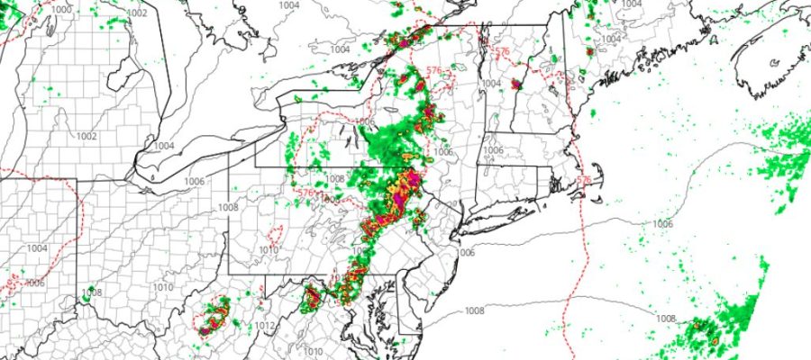
Northeast Severe Weather Possible This Evening
Good morning everyone. We have a hot one unfolding today as a ridge holds strong along much of the East Coast. Energy riding around that ridge will give the region a chance at some severe weather later this afternoon on into the evening hours. However, we’ll have to wait and see if those storms hold together as they trek towards NYC/Long Island.
SATELLITE

Today’s very hot forecast holds, with sun & clouds, humid conditions, and highs in the mid 90’s. Heat indexes will reach the 100-105 degree threshold. Look for that chance of late PM severe weather, especially in areas such as central/eastern PA and NW NJ. We’ll keep an eye on the radar to see of some of those storms survive the trip to the coast.
WEATHER RADAR

We’ll have more hot conditions tomorrow and another chance of PM storms. Tomorrow’s chance will be greater, and we’ll have more mid 90’s for highs.

Relatively drier air moves in for Saturday and Sunday, but we remain hot with near 90/low 90 temps for highs. Another front will swing through Sunday night, and we should find ourselves back to reality and in the low to mid 80’s Monday & Tuesday.
BE SURE TO DOWNLOAD THE FREE METEOROLOGIST JOE CIOFFI WEATHER APP &
ANGRY BEN’S FREE WEATHER APP “THE ANGRY WEATHERMAN!
MANY THANKS TO TROPICAL TIDBITS FOR THE USE OF MAPS
Please note that with regards to any severe weather, tropical storms, or hurricanes, should a storm be threatening, please consult your local National Weather Service office or your local government officials about what action you should be taking to protect life and property.