
Weather in 5/Joe & Joe Weather Show Latest Podcast
NYC Coastal Storm Makes Very Close Pass South Shore Long Island
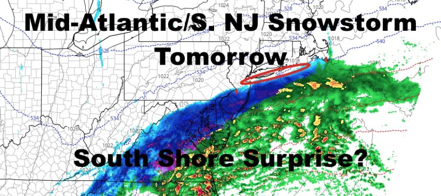
Good morning everyone and it’s good to be back! I’m being thrown right into the fire here with a very challenging forecast late overnight tonight and tomorrow for the South Shore and East End of Long Island. A coastal system is taking form and should hit parts of Virginia, Maryland, Delaware, and South NJ with some fairly hefty snow over a short amount of time. We’re watching this very closely, because a jog north of only 10-20 miles, could send some light to moderate snow into the South Shore and East End of Long Island.
SATELLITE

Today is a transition day as everything gathers up and cold air prepares to filter into the area. Expect cloudy skies and a few scattered showers around. Highs have already happened in the mid 50’s, and we should begin a slow decline throughout the day.
Overnight, cold air works in and lows should drop into the upper 20’s. That’ll surely make it cold enough for snow and for snow to stick if it falls. Again, we’re watching that northern line of precip very closely, and anything that does fall, if it falls, would start late overnight after 3am.
For tomorrow, we’ll be watching the south shores and Eastern Long Island again to see if that northern fringe of snow was able to make it north. If it doesn’t, expect a cloudy, cold, and raw day with highs in the low 30’s. If that snow does make it in, we could be looking at a 1-3/3-5″ type situation, with the bigger amounts possible out east.
WEATHER RADAR

Regardless of what happens, Tuesday is quiet, sunny, and seasonably cold w/ highs in the mid 30’s. Milder air works in for Wednesday, but it comes with clouds and the slight chance of showers. Highs in the mid to upper 40’s. Thursday we begin watching our next system for Friday as clouds increase and we hang out in the mid 40’s.

Your weekend is looking sunny and cold, with Saturday being the colder of the two. Highs will be in the low to mid 30’s Saturday, then mid to upper 30’s for Sunday.
BE SURE TO DOWNLOAD THE FREE METEOROLOGIST JOE CIOFFI WEATHER APP &
ANGRY BEN’S FREE WEATHER APP “THE ANGRY WEATHERMAN!

MANY THANKS TO TROPICAL TIDBITS & F5 WEATHER FOR THE USE OF MAPS
Please note that with regards to any severe weather, tropical storms, or hurricanes, should a storm be threatening, please consult your local National Weather Service office or your local government officials about what action you should be taking to protect life and property.