
COUPON CODE SUMMER24 GET 10% OFF
(Tempest is an affilllate of Meteorologist Joe Cioffi & earns commissions on sales.)
NYC Early Spring-Like Pattern Developing
Good morning everyone. It’s hard to mention the word “spring” when the NYC is still cold and we’re not remotely over yet with winter or prospects of snow, but the gears of spring are turning and we are seeing some subtle changes. Milder to warmer air is starting to push slightly further north into the Gulf and Southeast as contrasts grow sharper and more intense.
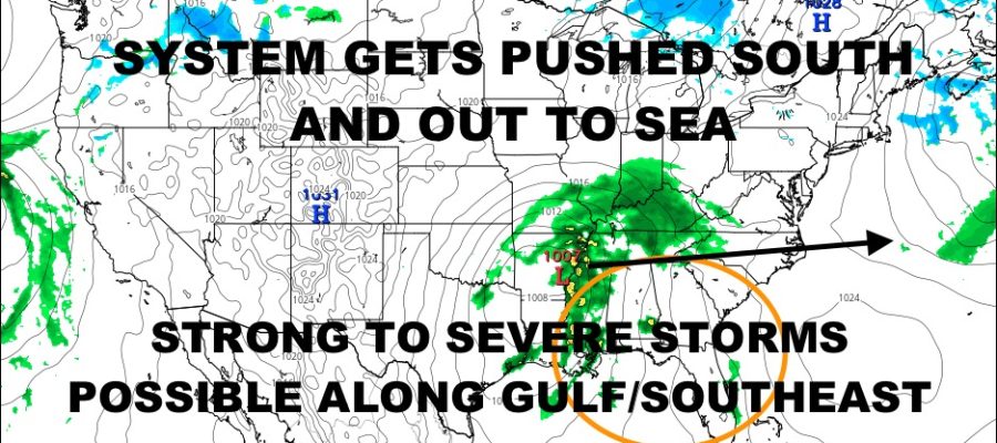
Our first system that everyone was excited about for Valentine’s Day weekend is a “bust”, but in my eyes, the “minimals” are happening. If you’ve been following my forecasts over the past week and a half, I stressed that the signs were there for a system, but that we didn’t know what it meant for the Northeast. I also stated that at minimum, the Gulf states and Southeast could be in trouble regarding heavy rain and storms.
The minimum is happening, and will will see some strong to severe storms this weekend across the Gulf and Southeast. We’ll also catch a break in the NYC this weekend and next week as temps modify a bit. While things won’t be perfect, part of these “gears of spring”, will be more and bigger breaks temp-wise in between systems. While there is still plenty of cold air available, I believe the worst is over as far as prolonged extreme, dangerously cold stuff.
Check out the latest below……
SATELLITE

Today looks sunny and blustery, but highs will at least break fast the freezing mark and into the mid 30’s. Look for more of the same tomorrow, with lighter winds for a more comfortable day.
WEATHER RADAR

Saturday will feel like spring with temps notching into the low 40’s. Clouds increase Sunday as that system slips to our south. We’ll be cooler due to the lack of full sun, with highs 35-40. Overnight, we could get clipped with a few light rain or snow showers, but nothing of significance.

Your workweek starts off really nice for this time of year, with sunshine and highs in the low 40’s. We could even see some mid 40’s for Tuesday with more sunshine. While the NYC won’t see it, 70-80 degree temps bubble up into Gulf States and Southeast for a sure sign that things are on the move. This is also where we see some of our more powerful systems and a historically notorious time for the Northeast, but we will won’t see bitter cold locked into the Northeast for weeks-on-end.
BE SURE TO DOWNLOAD THE FREE METEOROLOGIST JOE CIOFFI WEATHER APP &
ANGRY BEN’S FREE WEATHER APP “THE ANGRY WEATHERMAN!
MANY THANKS TO TROPICAL TIDBITS FOR THE USE OF MAPS
Please note that with regards to any severe weather, tropical storms, or hurricanes, should a storm be threatening, please consult your local National Weather Service office or your local government officials about what action you should be taking to protect life and property.