
COUPON CODE SUMMER24 GET 10% OFF
(Tempest is an affilllate of Meteorologist Joe Cioffi & earns commissions on sales.)
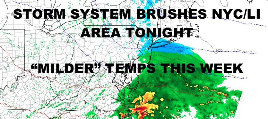
NYC Period of Snow Overnight
Good morning everyone. Our latest minor round of snow overnight tonight will be courtesy of a storm system we’ve been talking about for 2 weeks. Everything is unfolding as expected, with tornadic storms yesterday across the Gulf States; pushing into Georgia and Florida today. We also discussed the prospect of the NYC getting brushed with some snow, and that seems to be playing out nicely as well forecast-wise.
SATELLITE

Look for increasing clouds today with highs in the upper 30’s to low 40’s. Temps in the upper 20’s to low 30’s will help snow stick in some areas, but overall this is a light event. Expect a dusting to 1″ across the NYC and Long Island area, but we could see some isolated 2″ spots if some moderate snow sneaks in briefly. Snow is expected to begin some time between 12am and 4am, but should be gone just before or after sunrise.
WEATHER RADAR

Tomorrow we’re back into the upper 30’s, so most of anything that falls will melt. Sunshine returns on Tuesday with mid 40’s, then clouds increase again for a rainmaker on Wednesday. It’ll be a chilly rains with high in the low 40’s.

We’ll have a mostly cloudy day on Thursday with low 40’s, then some more rain and mid 40’s Friday. Overall, we don’t see anything extreme going on here; with no major arctic blasts in sight for the short/medium-range.
BE SURE TO DOWNLOAD THE FREE METEOROLOGIST JOE CIOFFI WEATHER APP &
ANGRY BEN’S FREE WEATHER APP “THE ANGRY WEATHERMAN!
MANY THANKS TO TROPICAL TIDBITS FOR THE USE OF MAPS
Please note that with regards to any severe weather, tropical storms, or hurricanes, should a storm be threatening, please consult your local National Weather Service office or your local government officials about what action you should be taking to protect life and property.