
Weather in 5/Joe & Joe Weather Show Latest Podcast
NYC Eeks Out Nice Workweek
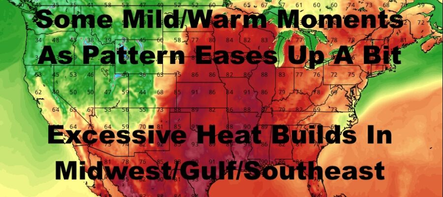
Good morning everyone. Sunshine has returned but low pressure sitting offshore is sending a lot of wind our way today and tomorrow. We’ll be on the seasonably cool side for the next few days, then the seasonably mild side for a few days after that. Away from the Northeast, excessive heat builds, and we may see an early season, record breaking heatwave in the Midwest, Gulf Coast, and Southeast.
SATELLITE

Sunshine is on tap for today with a few high clouds, but the big story is the wind. We’ll have a stiff onshore wind, with gusts near the coast possibly 35-40mph . Temps will be on the seasonably cool side, with slightly below average temps in the upper 60’s.
Sunshine remains tomorrow and winds calm down a bit, but it’ll still be breezy. We’ll also remain on the seasonably cool side in the upper 60’s.
WEATHER RADAR

Things calm down wind-wise on Wednesday, but we still remain in the upper 60’s. As low pressure retrogrades into the southeast, it’ll create a void to its west and north, allowing milder air to sneak in. Sunshine continues to stick around on Thursday and we climb into the low to mid 70’s. We’ll have AM sun, then increasing clouds on Friday and more low to mid 70’s.
The increasing clouds are in response to that low pressure nudging back west and into the Southeast. That’ll draw up some moisture as it dies out, and ride the western edge of high pressure up the coast. We’ll have the slight chance of a few showers Saturday, humid conditions, and mid to upper 70’s.
Extra clouds on Sunday will try and pay a visit. If the remaining energy is successful, we’ll have the chance of some more showers, more humid conditions, and upper 60’s to low 70’s for highs. If things fizzle out and we see more sunshine, we could see mid to upper 70’s.

In the long range, we have an equal opportunity for some seasonably mild to relatively warm temps, as well as unseasonably cool temps. We’ll watch the heat in the Midwest to see if the dynamics change, but right now I don’t see it breaking loose into the Northeast. It’ll be a big story though as 100 degree readings could be recorded up and down the Midwest, Gulf Coast, and parts of the Southeast in the upcoming long range.
BE SURE TO DOWNLOAD THE FREE METEOROLOGIST JOE CIOFFI WEATHER APP &
ANGRY BEN’S FREE WEATHER APP “THE ANGRY WEATHERMAN!

MANY THANKS TO TROPICAL TIDBITS & F5 WEATHER FOR THE USE OF MAPS
Please note that with regards to any severe weather, tropical storms, or hurricanes, should a storm be threatening, please consult your local National Weather Service office or your local government officials about what action you should be taking to protect life and property.