
COUPON CODE SUMMER24 GET 10% OFF
(Tempest is an affilllate of Meteorologist Joe Cioffi & earns commissions on sales.)
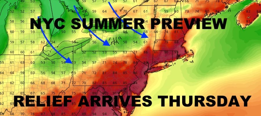
NYC Hot Stretch Through Wednesday
Good morning everyone. The heat is on as we get a 3 day taste of summer that will abruptly come to an end some time on Wednesday. We’re on the other side of our warm front, and we’ll remain that way until a cold front comes sweeping through in the form of gusty showers & storms Wednesday. Check out the latest below.
SATELLITE

For today, look for sunshine and highs near 90º (cooler at the shore). We turn things up a notch tomorrow, with highs 90-95. Best chance to see mid 90’s, possibly a touch higher, will be west of the City and downtown Brooklyn & Queens.
WEATHER RADAR

Wednesday is cold-front-day, but the timing on it looks to be mid to late afternoon. This will give us enough time to squeeze out another 90-95 degree day. Look for the risk of afternoon and evening gusty showers and storms. Some of these storms could be strong to severe in spots.

Things settle down Thursday with clouds and sun, breezy conditions, and highs in the upper 60’s to low 70’s. Clouds increase on Friday with the slight chance of showers. Highs in the mid 60’s.
BE SURE TO DOWNLOAD THE FREE METEOROLOGIST JOE CIOFFI WEATHER APP &
ANGRY BEN’S FREE WEATHER APP “THE ANGRY WEATHERMAN!
MANY THANKS TO TROPICAL TIDBITS FOR THE USE OF MAPS
Please note that with regards to any severe weather, tropical storms, or hurricanes, should a storm be threatening, please consult your local National Weather Service office or your local government officials about what action you should be taking to protect life and property.