
COUPON CODE SUMMER24 GET 10% OFF
(Tempest is an affilllate of Meteorologist Joe Cioffi & earns commissions on sales.)
NYC Light Snow Possible Monday
Good morning everyone. We have a snowy time along the lake shores of New York and Pennsylvania as cold air and wind move across the relatively warm Great Lakes. Otherwise, we have a windy day today as things gradually turn colder, then below average in the long range.
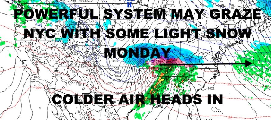
We’re also watching an important storm system that will form late in the weekend and impact the Midwest, Central States, and Gulf States in a big way. Low pressure will head out of the Rockies via the Pacific Northwest, hooking up with energy from the Gulf of Mexico. The contrast in air masses will be abrupt, and we will see a wide range of weather conditions in regards.
For parts of central and eastern Kansas, into upper Missouri, lower Illinois, and possibly into Indiana, heavy snow will dominate the scene. In a large swath, we will see an area of 1-2ft of snow occurring Sunday through Monday from west to east, and it’ll all fall in a relatively short time. Between the snow and heavy showers & thunderstorms expected, we will be looking at a narrow band of heavy sleet and freezing rain.
As of now it’s too soon to know exactly where the rain/snow/ice line will set up, but we do know that there will be some major travel hazards in all 3 aspects. For those who will be in the warm quadrant of this storm, we are expecting widespread severe weather. We’ll be watching parts of Oklahoma, Texas, Arkansas, and Louisiana for the first occurrences of severe thunderstorms; then Mississippi, Tennessee, Alabama, and Georgia as everything races east.
Look for the risk of damaging winds, large hail, frequent lightning, torrential rain, and the possibility of tornadoes as our system starts in Texas, and makes its way all the way to the Carolinas. As it does, look for some heavy showers and thunderstorms some time early Monday along the North Carolina and South Carolina coast. While we do not expect any widespread severe weather at this point, we could still see some embedded strong to severe weather.
As it all exits the East Coast, this system will be squeezed down and out somewhere by Virginia, Maryland, or North Carolina. On the northern fringe, look for some decent snows across parts of Virginia, southern Pennsylvania, Delaware, and Maryland. Depending on how far south everything gets pressed, we could see some light snows brush NYC and Long Island before everything slips well out to sea.
Here is your local NYC Metro forecast –
SATELLITE

Look for a mix of sun and clouds today, windy and chilly, with the slight chance of a few flurries in the afternoon. Highs will be in the upper 30’s to low 40’s.
WEATHER RADAR

Sunshine rules tomorrow through Sunday, with highs starting out in the mid to upper 30’s tomorrow; then low to mid 30’s for your weekend.

Clouds begin to increase Sunday night ahead of that system, and we have the chance of some light snow on Monday. Again, we’ll have to see how far north the outer fringe of precipitation is able to make it. Highs in the low 30’s.
BE SURE TO DOWNLOAD THE FREE METEOROLOGIST JOE CIOFFI WEATHER APP &
ANGRY BEN’S FREE WEATHER APP “THE ANGRY WEATHERMAN!
MANY THANKS TO TROPICAL TIDBITS FOR THE USE OF MAPS
Please note that with regards to any severe weather, tropical storms, or hurricanes, should a storm be threatening, please consult your local National Weather Service office or your local government officials about what action you should be taking to protect life and property.