
Weather in 5/Joe & Joe Weather Show Latest Podcast
NYC Messy Tuesday Expected
Good morning everyone and happy Sunday! We have a beautiful and seasonably cool day today, then the worm begins to turn starting later tomorrow. The end of the week into Halloween weekend pretty much looks the same, we just have to dial in on the timing; something that won’t happen today.
SATELLITE

Look for sunny skies today and very seasonable/seasonably cool weather for this time of year. We’ll have highs in the upper 50’s to low 60’s, then increasing clouds late as a warm front slides our way.
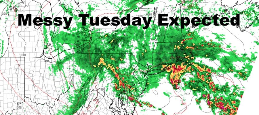
WEATHER RADAR

That warm front will give us a smorgasbord of conditions tomorrow. You’ll be waking up tomorrow to cloudy skies and maybe an early shower, then the sun will pay a visit for a few hours with some very mild conditions. It’ll be short-lived as clouds increase again and winds go maritime, which will be the sign of things to come for overnight tomorrow and Tuesday. Highs will be in the upper 60’s to low 70’s depending on how much sun we get.
For Tuesday, our warm front/cold front combo will transfer some energy to the coast to give us a Nor’easter-like setup. It’ll be “weak” in nature compared to the stuff we get late season and into the winter, but it’s going to give us a miserable day nonetheless. Rain will creep in overnight Monday, then we’ll have rain heavy at times on Tuesday. Winds will be out of the east at 7-15mph, with some gusty conditions during the heaviest of rain. If low pressure backs up towards Montauk and the Forks, they may locally see some stronger winds and heavier rain. Highs in the upper 50’s to low 60’s and raw/damp.
Things will be slow to clear on Wednesday as clouds stick around and the slight chance of some scattered showers. Temps will continue to hover in the low 60’s at best.
Thursday we clear out a bit, but could see increasing clouds late with our next system approaching. Highs in the low to mid 60’s.

Things remain the same for Halloween weekend as we watch our next system (after Tuesday’s). The only issue we have right now is the timing, and we might remain rain-free most of the day on Friday. If that happens, we’ll be shifting the timeline for rain for Friday night into Saturday.
Halloween itself remains looking solid forecast-wise, with clouds and sun, breezy conditions, and low to mid 50’s for highs.
BE SURE TO DOWNLOAD THE FREE METEOROLOGIST JOE CIOFFI WEATHER APP &
ANGRY BEN’S FREE WEATHER APP “THE ANGRY WEATHERMAN!

MANY THANKS TO TROPICAL TIDBITS & F5 WEATHER FOR THE USE OF MAPS
Please note that with regards to any severe weather, tropical storms, or hurricanes, should a storm be threatening, please consult your local National Weather Service office or your local government officials about what action you should be taking to protect life and property.