
COUPON CODE SUMMER24 GET 10% OFF
(Tempest is an affilllate of Meteorologist Joe Cioffi & earns commissions on sales.)
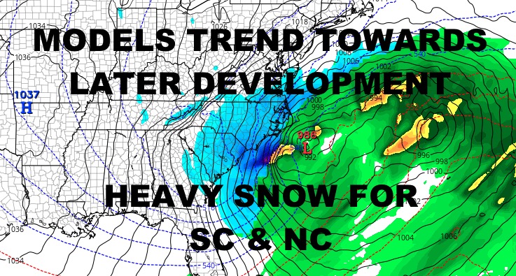
NYC Misses Snowstorm, Near-Blizzard Conditions Possible Carolina Coast
Good morning everyone. Models continue to trend our powerful storm further offshore and intensification slightly later, sparing the NYC with either nothing or some fringe effects; especially for the Forks of Long Island. Otherwise, this looks like a Carolina storm, with some heavy snow also possible across parts of Virginia. As of now and if things continue to trend this way, parts of coastal North Carolina could see up to a foot of snow and near-blizzard or blizzard conditions. Even areas such as Myrtle Beach, SC could see 3-6″+ of snow out of this. If things unfold this way, Myrtle Beach will have had 2 winters in a row with large winter storms.
SATELLITE

For today, arctic air grips NYC with upper teens to low 20’s for highs. Look for single digits to low teens overnight.
WEATHER RADAR

Tomorrow is even colder, with mid to upper teens for highs; and lows in the 5-10 degree range overnight.

Frigid air remains locked in on Saturday, and I believe the dense high pressure protects NYC from the storm. We’ll have highs 15-20, then lows in the low teens overnight as clouds increase. Look for the slight chance of some light snow or flurries before sunrise, then more of the same on Sunday with highs 20-25. It’ll be a blustery one as low pressure slips by well offshore. Along the east end of Long Island, we could see a brushing of 1-3″+ of snow if the storm edges closer.
BE SURE TO DOWNLOAD THE FREE METEOROLOGIST JOE CIOFFI WEATHER APP &
ANGRY BEN’S FREE WEATHER APP “THE ANGRY WEATHERMAN!
MANY THANKS TO TROPICAL TIDBITS FOR THE USE OF MAPS
Please note that with regards to any severe weather, tropical storms, or hurricanes, should a storm be threatening, please consult your local National Weather Service office or your local government officials about what action you should be taking to protect life and property.