
COUPON CODE SUMMER24 GET 10% OFF
(Tempest is an affilllate of Meteorologist Joe Cioffi & earns commissions on sales.)
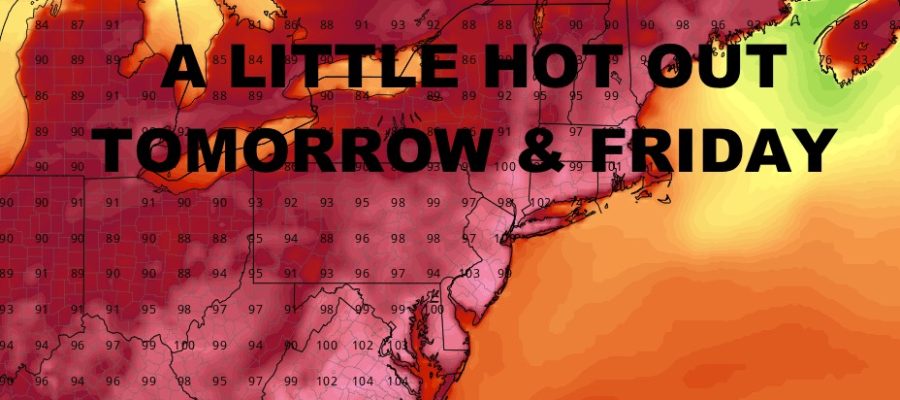
NYC Peak Heat Nears
Good morning everyone. Unless you’ve been living under a rock, most of you know we have a heatwave unfolding across the region. Once we get past this stretch, we also have heat that wants to return, but right now things look questionable as a pattern change wants to occur.
SATELLITE

For today, we have a sunny and hot one in the mid 90’s. Look for the slight risk of a scattered PM Storm. A reminder to everyone, those who do see thunderstorm action during this stretch, could see locally severe conditions.
WEATHER RADAR

Tomorrow we go extra toasty with highs in the 100-105º range. We’ll bring the risk of a scattered PM storm Friday, with highs still in the 100-105º range.

Depending on how much sun we get, near 100º temps are possible on Saturday; then we’ll have the chance of some PM showers & storms. Sunday “cools off”, with highs in the low 90’s and a better chance of PM showers & storms.
BE SURE TO DOWNLOAD THE FREE METEOROLOGIST JOE CIOFFI WEATHER APP &
ANGRY BEN’S FREE WEATHER APP “THE ANGRY WEATHERMAN!
MANY THANKS TO TROPICAL TIDBITS FOR THE USE OF MAPS
Please note that with regards to any severe weather, tropical storms, or hurricanes, should a storm be threatening, please consult your local National Weather Service office or your local government officials about what action you should be taking to protect life and property.