
COUPON CODE SUMMER24 GET 10% OFF
(Tempest is an affilllate of Meteorologist Joe Cioffi & earns commissions on sales.)
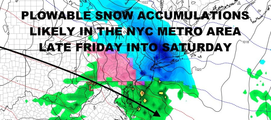
NYC Plowable Snow Likely Late Friday Into Saturday
Good morning everyone. We continue to watch our next system (which will be an odd-one at that) heading into the region Friday into Saturday. It’s been a fairly active winter so far, and we will slowly chip away at the average seasonal snowfall numbers. One more like this, and we could hit the average or at least get close.
SATELLITE

Sunshine rules today with chilly conditions and highs in the low 40’s at best. Clouds increase overnight as we dip into the upper 20’s to low 30’s, then we have a very slight chance of a mix of light rain and flakes tomorrow with highs in the 40-45 range.
WEATHER RADAR

We clear out overnight tomorrow night, but then clouds increase again Friday as cold air settles in. Highs will be near 30, setting us up for the next system. We don’t see this often, but low pressure will head out of the Great Lakes area, then get suppressed from northwest to southeast; well away from the area. Overrunning moisture will be ample as it hits that cold dome of air locked into the Northeast.
Look for light snow to develop late Friday, then steady snow overnight; possibly moderate to heavy at times. Snow continues on Saturday, and smaller flakes become bigger flakes as we rise into the mid 30’s (maybe). Don’t be surprised if you see things end as a light mix or light rain, especially on the south shore of Long Island and the Forks.
Snow accumulations will generally be in the 4-8″ realm, but we could see some higher amounts in spots, especially north and northwest of the City. We’ll also keep a close eye on where everything sets up, because a system like this will have a very wide range of accumulation amounts.

If things weren’t messy enough, we clear out and clouds return again on Sunday. It’ll be slightly milder in the low 40’s, with the chance of some rain. This will cause some sloppiness to ensue as roads become slushy w/ standing water in spots.
BE SURE TO DOWNLOAD THE FREE METEOROLOGIST JOE CIOFFI WEATHER APP &
ANGRY BEN’S FREE WEATHER APP “THE ANGRY WEATHERMAN!
MANY THANKS TO TROPICAL TIDBITS FOR THE USE OF MAPS
Please note that with regards to any severe weather, tropical storms, or hurricanes, should a storm be threatening, please consult your local National Weather Service office or your local government officials about what action you should be taking to protect life and property.