NYC Snow Deficit Brings Us To March
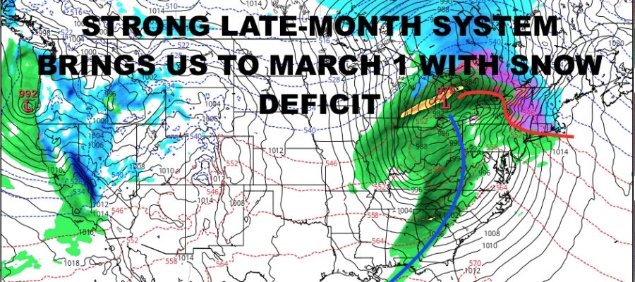
Good morning everyone. Although we have some cold air sneaking in here and there, with the chance of some mixed precip and/or light snow, we’re heading into the first week of March with hardly any snow. A very large system towards the end of month that’ll keep us in the “warm” sector with its West and North track, will seal the deal for February and put us in a very bad spot to start March.
SATELLITE

We’ll have cloudy skies today as rain has moved off the coast at this point. Expect highs near 50 today, with maybe a few blue breaks added a degree or two if it happens. We could also see the chance of another afternoon shower here and there.
Clouds will increase again tomorrow with the chance of a few late showers. We’ll have highs in the mid 40’s/ Overnight tomorrow, we could see some rain mixed with wet snow or sleet pellets, but then it goes back to all rain as you wake up Thursday AM.
WEATHER RADAR

We’ll see some morning rain on Thursday with highs near 50, then it gets more windy as colder air starts to filter in. Friday is looking blustery and cool with low to mid 40’s, then downright cold overnight with lows in the upper teens to low 20’s.
Your weekend is looking cold to start, with increasing clouds and highs in the low to mid 30’s. NWS is calling for the chance of some light snow or rain/snow mix, but I’m not convinced this even happens at all. As of now, I’m just going to call for increasing clouds, then decreasing clouds Sunday w/ highs 45-50. I think most of the energy goes well to the north and to the south of us.

In the long range, we have another powerful system heading into the Great Lakes region to end February. That’ll equate to more rain, more wind, and colder conditions behind it. It also means we enter “Meteorological Spring” with a historic/near-historic snow deficit. In order to evade some of our previous records, we will need 2-3″ of snow at some point during March and April. Can it happen? Yes, but it gets harder and harder when you equate warmer-than-average-ocean temps into the mix.
This means you will need the perfect overrunning setup for some light snow sneaking in, or an absolute monster storm with the perfect strength, timing, and path, all while coinciding with and having access to very cold air.
BE SURE TO DOWNLOAD THE FREE METEOROLOGIST JOE CIOFFI WEATHER APP &
ANGRY BEN’S FREE WEATHER APP “THE ANGRY WEATHERMAN!
MANY THANKS TO TROPICAL TIDBITS & F5 WEATHER FOR THE USE OF MAPS
Please note that with regards to any severe weather, tropical storms, or hurricanes, should a storm be threatening, please consult your local National Weather Service office or your local government officials about what action you should be taking to protect life and property.