
NYC SNOW HIGHLY UNLIKELY

NYC SNOW HIGHLY UNLIKELY
NYC SNOW HIGHLY UNLIKELY – Good morning everyone and welcome to another rainy day in NYC. Another system is approaching the area and it is unlikely we’ll see any cheap thrills out of this low pressure system. If you happen to be up or looking outside when the precip begins in the first part of the morning, you may see a few wet snowflakes mix in with rain, but thats about it before becoming a cold, steady rain. A wave will begin to form to our south and west along a frontal boundary, giving us an maritime fetch and the kiss of death for any chance of snow with a gusty southeast wind, keeping any cold air from sticking around. This is a quick mover, so it should be in and out by late evening today, but not before dropping about a 1/2″ of rain in the NYC area.
Colder air ushers back in tonight, with partial clearing, gusty west winds, and lows in the low 30’s. Friday will remain windy, with the chance of a few widely scattered rain/snow showers and highs near 40. Saturday will be the coldest day of the weekend, with sunny skies and highs in the upper 30’s. For New Years Eve, a weak disturbance will pass over the area, possibly touching off some scattered light rain and snow showers as the Ball drops at Times Square. Things clear out again on Sunday, with a beautiful New Years Day, sunny skies and highs near 45.
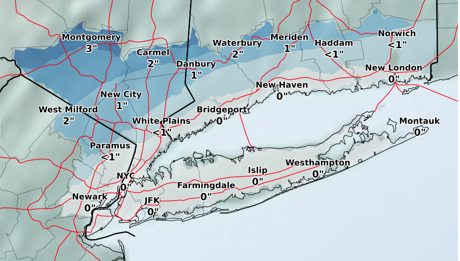
NYC SNOW HIGHLY UNLIKELY – Snow totals even to our North and West looks rather unremarkable as this will primarily be an upper New England storm in central parts of Maine, Vermont, and New Hampshire, with snowfall amounts 12-18″ in the upper elevations.

Satellite depicts our next systems chugging along the Ohio valley and Appalachian chain.

NE Radar is starting to show our rain beginning to enter the picture, local radar still very quiet, but will become more active later this morning.

FiOS1 News Weather Forecast For Long Island
FiOS1 News Weather Forecast For New Jersey
FiOS1 News Weather Forecast For Hudson Valley
NATIONAL WEATHER SERVICE SNOW FORECASTS
LATEST JOESTRADAMUS ON THE LONG RANGE

Weather App

Don’t be without Meteorologist Joe Cioffi’s weather app. It is really a meteorologist app because you get my forecasts and my analysis and not some automated computer generated forecast based on the GFS model. This is why your app forecast changes every 6 hours. It is model driven with no human input at all. It gives you an icon, a temperature and no insight whatsoever.
It is a complete weather app to suit your forecast needs. All the weather information you need is right on your phone. Android or I-phone, use it to keep track of all the latest weather information and forecasts. This weather app is also free of advertising so you don’t have to worry about security issues with your device. An accurate forecast and no worries that your device is being compromised.
Use it in conjunction with my website and my facebook and twitter and you have complete weather coverage of all the latest weather and the long range outlook. The website has been redone and upgraded. Its easy to use and everything is archived so you can see how well Joe does or doesn’t do when it comes to forecasts and outlooks.
Just click on the google play button or the apple store button on the sidebar for my app which is on My Weather Concierge. Download the app for free. Subscribe to my forecasts on an ad free environment for just 99 cents a month.
Get my forecasts in the palm of your hand for less than the cost of a cup of Joe!
