NYC SOAKER AHEAD BRIEF WINTRY MIX POSSIBLE LATE WEEK
Good morning everyone. We have another soaker heading our way here in New York City, but not before we squeeze out one more decent day. Meanwhile, even colder air is heading our way. This could result in a brief wintry mix if timed right with stubborn-enough cold air, as yet another system approaches late week.
EASTERN SATELLITE

For today, sunny skies will dominate before clouds increase late. We’ll have a light southerly breeze before slowly switching to the southeast, then east in the late evening; highs 45-50.
REGIONAL RADAR

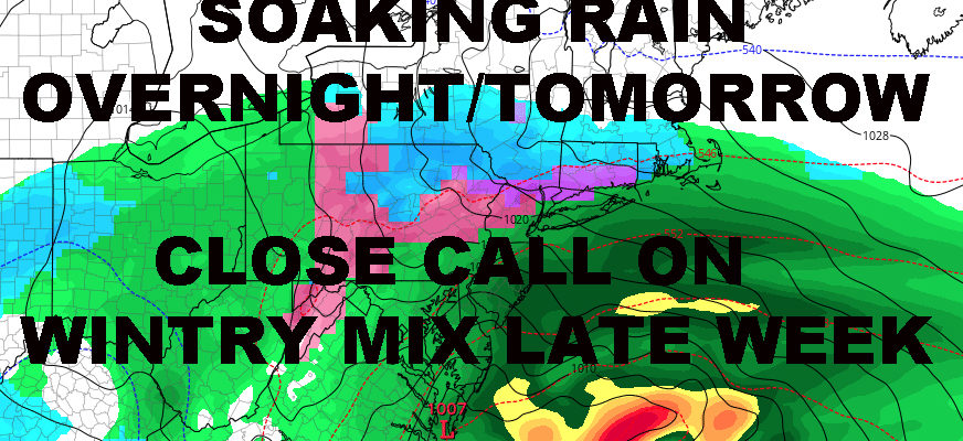
The radar is clear for now, but it’ll fill up fast later tonight with rain heading in after midnight thanks to a system coming up from the southwest. Low pressure will gather strength near the coast, then zip on by; giving us a windswept rain overnight and into early tomorrow. Expect a stiff ESE breeze with gusts to near 30 in most spots, possibly 35-40 along the immediate shore. We should also see your staple 1-2″ rain totals out of this, with some locally higher amounts. Watch out for ponding on roads and localized flooding in the usual trouble spots. Highs tomorrow will be in the 50-55 range, but it’ll be a raw one even though the rain is gone by late morning/early afternoon.
LOCAL RADAR NEW YORK CITY

We drop like a rock back into the low 30’s overnight tomorrow, with some 20’s in outlying areas as cold air rushes back in. After having the coldest air of the season this past weekend, we’ll beat that with the coldest air of the season for Wednesday and Thursday. Expect a cold day on Wednesday, with a stiff NW breeze and highs only in the upper 30’s to low 40’s. Then on Thursday, we’ll have highs near 40, with increasing clouds due to our next approaching coastal-runner.
LOCAL RADAR PHILADELPHIA


With cold air locked in on Thursday and highs in the upper 30’s to near 40 as moisture approaches, we’ll have to see how stubborn that cold air is, how strong that system is, and what kind of path/timing we’re talking about; all things too early right now to pinpoint. This is the problem when we’re looking at systems beyond systems. We have to wait and see what everything looks like behind our system tonight and tomorrow, to get an idea how stubborn this air might be along with what path we’re looking at.
Regardless, we have the possibility that our precip late Thursday may start out with some pellets of sleet and/or wet snow mixed in if cold air aloft is stubborn. At minimum, we’ll have a very cold December-like rain with steady snows possible for interior parts in New York and New England.
For our Hail-Mary Thanksgiving outlook, a cool and sunny Thanksgiving is still holding very strong.
FiOS1 News Weather Forecast For Long Island
FiOS1 News Weather Forecast For New Jersey
FiOS1 News Weather Forecast For Hudson Valley
NATIONAL WEATHER SERVICE SNOW FORECASTS
LATEST JOESTRADAMUS ON THE LONG RANGE