DOWNLOAD MY NEW FREE JOESTRADAMUS WEATHER APP FOR ALL DEVICES
THE APP IS ABSOLUTELY FREE TO ALL BUT CONSIDERING SUBSCRIBING TO PATREON FOR A WEATHER EXPERIENCE FREE OF ADS, EXCLUSIVE VIDEOS FOR MEMBERS ONLY AND MUCH MORE…STARTS AT $2 A MONTH..MESSAGE ME AT ANY TIME
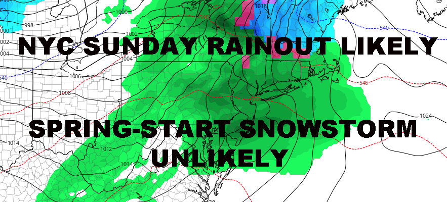
NYC SUNDAY RAINOUT EXPECTED NO BIG SNOWS EXPECTED
Good morning everyone. So far so good is the best way to describe how March is unfolding for the NYC area in regards to the March outlook posted in February. We have our cold air in place which will slowly modify, then give way to a more rainy and seasonal pattern. I know people are itching for a big March Blockbuster Snowstorm or a Big Spring 70’s Breakout, but you’ll get neither and middle of the road it is.
EASTERN SATELLITE

Sun and clouds rule today as another weak spoke of energy comes down from the Great Lakes. We’ll have the slight chance of a few flurries again today, but since yesterday wasn’t very successful as flurries dried out before getting here, don’t expect today to be very successful either. However, I’ll keep it in the forecast in case a stray one makes the trip; and I can avoid someone sending me video of a single flake falling out of the sky titled, “You were wrong, it did snow.” Highs today in the low 30’s.
REGIONAL RADAR

Tomorrow, that icy veil of clouds expected to drift our way remains on time. That’s associated with a weak system slipping to our south. I remain skeptical as to our chances of some light snow, but there’s a slight chance as everything passes on by and the most northern fringe may brush us. We’ll modify a bit into the mid to upper 30’s tomorrow, so anything that does fall prior to sunset will melt. anything after sunset may stick, but again, the chance is so slight.
IF we do get anything at all, expect nothing of consequence and I’m not even wasting time with a snow map.
LOCAL RADAR NEW YORK CITY

For Saturday, we modify into the low to mid 40’s with a sunny start; then clouds increase late and winds switch to that vaunted easterly direction. That’s the signal of yet another approaching system, but this one will be going well north and west of us.
We’ll have the slight chance of rain Saturday night, then that chance increases by or just before sunrise on Sunday. Expect on and off rain all day on Sunday with highs in the upper 40’s to near 50.
Next week starts off near-seasonal, with sunny skies and a stiff breeze on Monday. Highs again in the upper 40’s to near 50, then we cool off a bit to start the rest of the week. We’ll remain near or slightly below normal until the arrival of our next system late week, and it’s looking like the familiar north and west track we’ve had for most of the season.
The long range continues to look active, mostly seasonal, with the only milder air available to be associated with approaching systems; so it’ll be brief in nature. Until we warm up that Southeast, there’s not much mild air to pump up even when things work out “right”. On the bright side, we’re starting to close the book on winter and snow chances are becoming more and more elusive.
MANY THANKS TO TROPICAL TIDBITS FOR THE USE OF MAPS
Please note that with regards to any tropical storms or hurricanes, should a storm be threatening, please consult your local National Weather Service office or your local government officials about what action you should be taking to protect life and property.