
Weather in 5/Joe & Joe Weather Show Latest Podcast
NYC Uncertainty Remains With Very Small Tolerances Setting Up
Good early afternoon everyone. We’re starting to watch all of the players come into view that’ll create our winter storm for late Friday/Saturday. Things are looking good in most instances, but tough in others. I’ll explain below.
SATELLITE

For the time being, we are quiet and sunny, but the ingredients are gathering up for an interesting time Friday night into Saturday. We’ll have sunshine all day, with highs in the upper 20’s to near 30.
Clouds increase tomorrow, then we’ll have the slight chance of light snow late in the evening/at night. Highs tomorrow will be in the mid 30’s, so anything that does fall early will melt at first. Lows overnight plummet into the teens as low pressure pulls down frigid air down from the north.
WEATHER RADAR

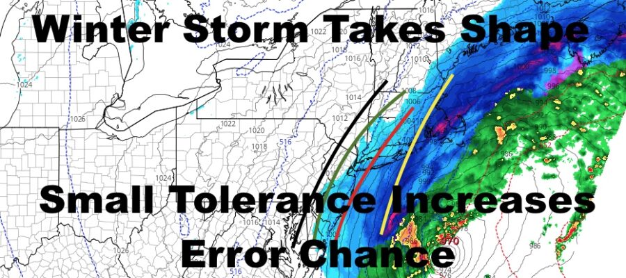
We’re going to do something unconventional here and not create a snow map. We’ll probably hold off till tomorrow AM due to the tight differences and issues with dry air to our west. I continue to stick with the 2-4/3-6/4-8″ range from west to east, with an 8-12″ range setting up at or near the Suffolk County line. Best chance to see 12+ will be the Forks of Long Island.
Highs Saturday during this thing will be a brutal low 20’s with very windy conditions. Any accumulating snow comes to an end west to east rather quickly and some time from noon/early afternoon onward.

If we do have some snow cover, NWS is not doing a good job taking that into consideration as far as temps for Sunday/Monday. Expect very cold conditions, with mid to upper 20’s Sunday, then upper 20’s Monday depending on snow pack. Teens be the flavor each night, including low teens for Saturday as our system departs.
BE SURE TO DOWNLOAD THE FREE METEOROLOGIST JOE CIOFFI WEATHER APP &
ANGRY BEN’S FREE WEATHER APP “THE ANGRY WEATHERMAN!

MANY THANKS TO TROPICAL TIDBITS & F5 WEATHER FOR THE USE OF MAPS
Please note that with regards to any severe weather, tropical storms, or hurricanes, should a storm be threatening, please consult your local National Weather Service office or your local government officials about what action you should be taking to protect life and property.