
Weather in 5/Joe & Joe Weather Show Latest Podcast
NYC Windy Rainy October System Moving In
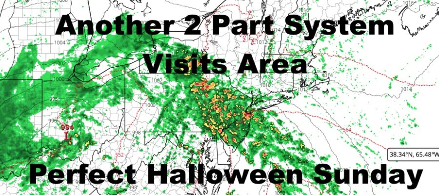
Good morning everyone. We’re up early here today to take care of some important business, and there’s a lot to discuss with our next system heading in. First and foremost, this one is not a Nor’easter, but there will be a few similarities. The first similarity will be the 2 part “design”. The second, will be the potential for flooding rain during the first part; primarily due to the rain from our early week Nor’easter. I also believe that the NWS has certain things wrong about this system, and I’ll discuss that below.
SATELLITE

We’ll start off cloudy this morning with an easterly wind building and becoming more steady. We could see some scattered sprinkles or light showers come mid to late afternoon, but I believe the heaviest/steadiest rain holds off till nighttime; some time between 8-11pm. Highs in the 55-60 range.
We’ll have rain, heavy at times, with the chance of a few rumbles of thunder overnight. The biggest flash flooding risk will happen during this round of precip. I think the heaviest of rain is gone between 3 and 5am, then we settle into a more showery-type situation.
We’ll also have enhanced tides and minor coastal flooding due to the prolonged easterly fetch and winds gusting to near 40-45mph along the immediate shore (lower away from the coast). The winds are in response to the strong frontal boundary and not a Nor’easter-type low pressure. It is a typical setup we see in October/November as we pivot towards late fall/winter.
WEATHER RADAR

Tomorrow is somewhat complicated in terms of precipitation and timing. You’ll notice the winds die down considerably from overnight and there will be a lull in the action. We could see some early AM showers, then fast moving, scattered light/moderate showers and sprinkles redeveloping later in the morning. On & off showers will be with us all day; then another wave of low pressure riding the old front off of the coast will shoot south to north near Montauk and into New England.
This process will begin later in the afternoon tomorrow and into the evening. Expect a steadier rain to develop around the NYC Metro Area, but Suffolk County could see another burst of heavy rain in the evening and into the night. Highs tomorrow will be 60-65 range.

As low pressure movies well into New England and Canada, it’ll leave a soft cushion of sinking air south of it. This will open up the window for clearing skies on Halloween Sunday, a gentle westerly breeze, and highs 60-65. While we’ve had warmer Halloweens in the past, this is about as good as it normally gets this time of season. Enjoy!
BE SURE TO DOWNLOAD THE FREE METEOROLOGIST JOE CIOFFI WEATHER APP &
ANGRY BEN’S FREE WEATHER APP “THE ANGRY WEATHERMAN!

MANY THANKS TO TROPICAL TIDBITS & F5 WEATHER FOR THE USE OF MAPS
Please note that with regards to any severe weather, tropical storms, or hurricanes, should a storm be threatening, please consult your local National Weather Service office or your local government officials about what action you should be taking to protect life and property.