
SLOW SYSTEM STUBBORN DRY AIR COMPLICATE NYC FORECAST
Good morning everyone. If you take a look back at my previous forecasts the last few days for the New York City area, everything is unfolding the way it was expected in my mind. Add a new feature into the mix, stubborn dry air, and it completes the circle of how tough this forecast really is.
Complicated NYC Forecast
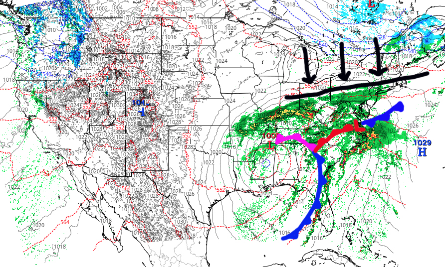
- Primary Low Hanging back from the coast – check
- A stretched out, wide reaching system – check
- A wave of energy forming off of the coast – check
- System path not snow-friendly for NYC – check
- Slow moving system lingering all weekend – check
- Dry air pushing down, limiting precip? – Well, damn
….and there you have it. Clouds are in for good for the next several days as everything comes together, but not exactly. Look for upper 40’s today with spotty drizzle and/or light rain by late afternoon/early evening. Highs in the upper 40’s to low 50’s but raw.
Light rain and drizzle continue into the night, then we may get into some steadier rain a few hours before sunrise tomorrow. However, flooding is not a concern at this time since things will be slow and steady.
REGIONAL RADAR

As stated yesterday, I saw a big problem reaching big rain totals and thought an inch is about all we’ll get out of this. This looks to be the case and it’s looking like a slow inch as well. IF dry air doesn’t fight back as hard, we could see some locally higher amounts if that wave off of the coast can inch a notch north, but that is in doubt right now. Expect another raw upper 40’s to near 50 day tomorrow as the northeast breeze becomes steady.
LOCAL RADAR NEW YORK CITY

For Sunday, it’s almost a lock now that stubborn showers and clouds stick around. It’ll be a cold rain as highs only get into the low to mid 40’s. It won’t be a complete rainout, but look for periods of rain for another gloomy, awful day. I also maintain that we could see a few wet flakes mixed in Sunday night as things begin to pull out and that colder air works its way into the atmosphere.
LOCAL RADAR PHILADELPHIA


After some early morning clouds and drizzle, things begin to slowly clear on Monday and the cold air returns. We’ll see some mid 40’s if the sun returns on Monday, then we drop into the mid 30’s for Tuesday.
The internet is abuzz about the possibility of a storm just before and after Christmas, but confidence is very low as everything looks piece-meal like the system we are about to deal with.
FiOS1 News Weather Forecast For Long Island
FiOS1 News Weather Forecast For New Jersey
FiOS1 News Weather Forecast For Hudson Valley
NATIONAL WEATHER SERVICE SNOW FORECASTS
LATEST JOESTRADAMUS ON THE LONG RANGE