SHOP THE JOESTRADAMUS STORE
FOR YOUR ANGRY BEN OR JOLLY JOESTRADAMUS CHRISTMAS MUG
ANOTHER NYC SNOW SHOT TONIGHT
ANOTHER NYC SNOW SHOT TONIGHT
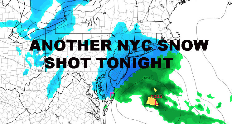
ANOTHER NYC SNOW SHOT TONIGHT – Good morning everyone. Cold air remains in place and yet another small shot of snow is heading our way for later this evening and overnight.
As of now we have a cloudy and cold morning unfolding with temps in the low 20’s. Clouds will continue to thicken throughout the day as low pressure will develops quickly off of our coast. It’ll slip south of the area, but gather strength quick enough and throw back a shield of snow over the New York City metro area.
Just like our previous system, eastern Long Island looks to gain the most with this system, with 2-4″ possible from central Suffolk County on east. However, New York City will get in on the action as well, with 1-2″ possible in the area. Areas east of NYC, such as Nassau County and Western Suffolk, should see 1-3″ with this quick shot of snow.
After we get past this, things relax somewhat. We’ll have sunny skies and upper 30’s for both tomorrow and Sunday, then we return to normal with mid 40’s; sun and clouds on Monday. On Tuesday we’ll be slightly above normal, with highs near 50, then we return to low 40’s mid to late week next week.
The long range remains active, with several systems that could provide us with some frozen or mixed precip given the “right” path, but that remains to be seen and too far out. Our bitter cold air takes a slight reprieve, with more ups and downs than anything else. However, very cold air will begin to recharge in Canada and get ready for another invasion possibly late in the month.
NATIONAL WEATHER SERVICE SNOW FORECASTS
LATEST JOESTRADAMUS ON THE LONG RANGE
Weather App
Don’t be without Meteorologist Joe Cioffi’s weather app. It is really a meteorologist app because you get my forecasts and my analysis and not some automated computer generated forecast based on the GFS model. This is why your app forecast changes every 6 hours. It is model driven with no human input at all. It gives you an icon, a temperature and no insight whatsoever.
It is a complete weather app to suit your forecast needs. All the weather information you need is right on your phone. Android or I-phone, use it to keep track of all the latest weather information and forecasts. This weather app is also free of advertising so you don’t have to worry about security issues with your device. An accurate forecast and no worries that your device is being compromised.
Use it in conjunction with my website and my facebook and twitter and you have complete weather coverage of all the latest weather and the long range outlook. The website has been redone and upgraded. Its easy to use and everything is archived so you can see how well Joe does or doesn’t do when it comes to forecasts and outlooks.
Just click on the google play button or the apple store button on the sidebar for my app which is on My Weather Concierge. Download the app for free. Subscribe to my forecasts on an ad free environment for just 99 cents a month.
Get my forecasts in the palm of your hand for less than the cost of a cup of Joe!


