BEAUTIFUL WARM NYC EASTER SUNDAY AHEAD
BEAUTIFUL WARM NYC EASTER SUNDAY AHEAD
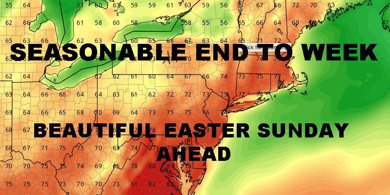
BEAUTIFUL WARM NYC EASTER SUNDAY AHEAD – Good morning everyone! Cooler air has moved into the area with the passage of a cold front late yesterday, but it only feels cool compared to the warm air we’ve had the past few days. What we really have is a return to seasonable temps, which will be with us the next few days before warm air returns on Sunday.
Sunny skies will prevail today, with breezy conditions and highs in most areas in the upper 50’s to low 60’s. Similar weather tomorrow, but the winds will calm down a bit to make it feel a touch warmer, highs in the low 60’s. On Saturday, a thin veil of clouds will move in ahead of the warm air and we’ll have partly sunny conditions, highs in the low 60’s. We’ll have a shot at some scattered light rain overnight Saturday as the warm airmass moves in, but things will clear out by Sunday morning.
For Easter Sunday, warm air returns, with sunny skies and highs near 80 in the NYC area. As typical with springtime, we’ll have cooler temps at the coast and a few areas cracking 80 in the notoriously warmer spots in the City. Overall, you couldn’t ask for better weather for the holiday and it’ll be a beautiful day. Cooler air sinks back down for Monday, but temps will still be above normal for one more day with highs near 70.
Tuesday, we dip down to near normal, maybe slightly below depending on how much cool air works in; highs for now will be 55-60. On Wednesday, temps bounce back a few degrees with a slight chance of some rain. Overall in the long range, we have seasonal temps and a few chances of rain, but there is plenty of room between systems to enjoy a few good blocks of sun and mild weather. We also have to keep an eye on a cool start to May or cool end of April, but it looks to be short lived if it does happen as heat builds again in the midwest and drifts eastward.
Satellite View

BEAUTIFUL WARM NYC EASTER SUNDAY AHEAD – Cooler air has moved back in as several small systems spin across the Nation, but we’re in for a big, short-lived warmup on Easter Sunday.
Northeast Radar
Radar is quiet and will remain so until a few light showers transit the area on Saturday night.
FiOS1 News Weather Forecast For Long Island
FiOS1 News Weather Forecast For New Jersey
FiOS1 News Weather Forecast For Hudson Valley
NATIONAL WEATHER SERVICE SNOW FORECASTS
LATEST JOESTRADAMUS ON THE LONG RANGE
Weather App
Don’t be without Meteorologist Joe Cioffi’s weather app. It is really a meteorologist app because you get my forecasts and my analysis and not some automated computer generated forecast based on the GFS model. This is why your app forecast changes every 6 hours. It is model driven with no human input at all. It gives you an icon, a temperature and no insight whatsoever.
It is a complete weather app to suit your forecast needs. All the weather information you need is right on your phone. Android or I-phone, use it to keep track of all the latest weather information and forecasts. This weather app is also free of advertising so you don’t have to worry about security issues with your device. An accurate forecast and no worries that your device is being compromised.
Use it in conjunction with my website and my facebook and twitter and you have complete weather coverage of all the latest weather and the long range outlook. The website has been redone and upgraded. Its easy to use and everything is archived so you can see how well Joe does or doesn’t do when it comes to forecasts and outlooks.
Just click on the google play button or the apple store button on the sidebar for my app which is on My Weather Concierge. Download the app for free. Subscribe to my forecasts on an ad free environment for just 99 cents a month.
Get my forecasts in the palm of your hand for less than the cost of a cup of Joe!


