Dry Conditions in New York City Till Wednesday
04/07/24 10:29am ET
Good morning everyone. We are finally fully drying out and clearing all of the cloud cover out of the Northeast, replacing gloomy weather with sunny & calm conditions until Wednesday. We’ll also be watching for a very mild day on Tuesday, where 70+ degrees will be commonplace in New Jersey, the Lower Hudson Valley, NYC, and parts of Long Island.
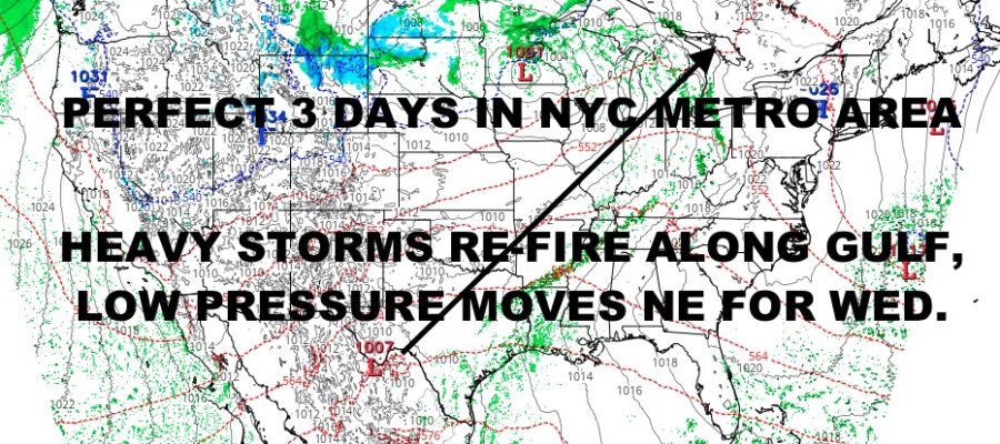
The reason why Wednesday won’t be very nice in the Northeast, is due to events about to unfold in the Gulf States and lower Midwest. Yesterday we saw severe weather rake Nebraska, Kansas, Oklahoma, and parts of South Dakota. Today, we’ll watch that risk for severe weather reemerge in parts of Texas, Louisiana, Arkansas and southeast Oklahoma.
Our front from yesterday stalls out, and low pressure from southwest Texas begins to create a new frontal boundary ahead of it in east Texas/Louisiana. This will create slow-moving storms with flooding rain and isolated severe weather. While flooding rain is the biggest risk, isolated cells will be capable of large hail and isolated tornadoes. The timeline on this is late in the evening tonight, into the overnight hours, and into Tuesday. This will be a long event, so be sure to watch the radar closely and stay tuned to your local broadcast system for flood warnings and isolated severe storms that may pop up.
Here is your local NYC Metro forecast –
SATELLITE

Look for sunshine today and lighter winds, highs in the 50-55 range. We’re chilly overnight and in the mid to upper 30’s, but then mild air begins to creep in tomorrow.
WEATHER RADAR

Tomorrow is a winner, with sunshine and low 60’s. Tuesday is the mildest day of the week as we go for 70-75 in spots (cooler at the shore). Clouds will increase late, but not enough to impact the day.

Look for on and off rain on Wednesday, with raw conditions in the 50’s. We go milder on Thursday ahead of the front, with more rain, heavy at times, breezy, and 60-65.
BE SURE TO DOWNLOAD THE FREE METEOROLOGIST JOE CIOFFI WEATHER APP &
ANGRY BEN’S FREE WEATHER APP “THE ANGRY WEATHERMAN!
MANY THANKS TO TROPICAL TIDBITS & F5 WEATHER FOR THE USE OF MAPS
Please note that with regards to any severe weather, tropical storms, or hurricanes, should a storm be threatening, please consult your local National Weather Service office or your local government officials about what action you should be taking to protect life and property.