GULF COAST SEVERE SLAM POSSIBLE BEFORE CAROLINA SNOW
Good morning everyone. It’s pretty much written in stone now that our late weekend to early week system is a done deal for New York City in terms of it not happening, but other parts of the Country will suffer it’s wrath. While many are focused on the snow story, there are big problems that the Gulf Coast will experience first.
EASTERN SATELLITE

For us, dry and cold will be the theme for the next week at least. The only chance of any snow (or anything for that matter) will be overnight tonight as a reinforcing shot of cold air digs in. Expect sunny skies today, then increasing clouds late, highs in the mis to upper 30’s. We’ll have the slight chance of some snow showers or flurries scattered about tonight, then things will clear out long before sunrise tomorrow. No accumulation is expected and not everyone is going to even see a flake.
REGIONAL RADAR

With reinforcing shot after reinforcing shot of relatively cold air for the season, our forecast is like slow pitch softball. Expect sunny skies and dry conditions from today, all the way till at least next Thursday; with highs in the mid to upper 30’s, possibly 40 in some spots, this entire block.
LOCAL RADAR NEW YORK CITY

That cold, dry air helps shut off the possibility of anything making it up our way, including the system trekking across the Country this weekend and early next week.
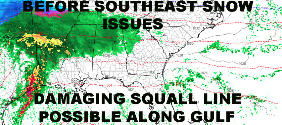
This will be a textbook Gulf-creeper, with heavy snows possible in the panhandle of Texas and the lower Midwest; and in the warm sector; severe weather. Look for a clearly defined squall line to develop ahead of that Gulf low, where strong, damaging winds, large hail, and isolated tornados will be a widespread issue from Texas to the panhandle of Florida.
LOCAL RADAR PHILADELPHIA


As everything slides to the coast, our cold air will dig in far south, giving areas such as upstate SC, western NC, and VA the chance of some heavy snows. It’s too early to say how much the area of heavy snow will extend, but at minimum, mountainous areas and parts of the piedmont will see possibly a foot plus of the white stuff.
How close those heavy snows get to areas such as Charlotte, Raleigh, and Greenville-Spartanburg, remains in question.
Stay tuned as we watch the whole thing unfold from our cold and dry dome of nothingness.
FiOS1 News Weather Forecast For Long Island
FiOS1 News Weather Forecast For New Jersey
FiOS1 News Weather Forecast For Hudson Valley
NATIONAL WEATHER SERVICE SNOW FORECASTS
LATEST JOESTRADAMUS ON THE LONG RANGE