Late Weekend Forecast Remains Complicated Small Accumulations Possible During Start Finish
Good morning everyone. We wake up this morning and not much has changed in my opinion in terms of forecasting Sunday into Monday night. We have a lot of pieces which need to come together perfectly in order to get snow lovers a taste of winter. When you see all of the things that need to happen, it creates this void in which we could get both an upside surprise, downside surprise, or neither.
SATELLITE

We’ll start off easy and discuss today and tomorrow. Expect sunny skies today, with a steady northerly flow, and a chilly feel with low to mid 40’s as highs.
Tomorrow is just about the same, but winds relax a bit and AM sun will give way to increasing clouds late. Highs tomorrow in the low 40’s and chilly.
REGIONAL RADAR

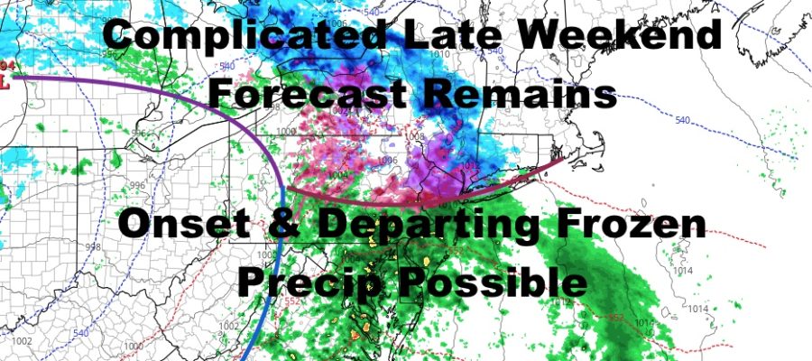
Clouds continue to increase overnight Saturday, and lows in the upper 20’s to low 30’s could spell trouble for Sunday morning. Low pressure will head through the Great Lakes region with moisture stretched out way ahead of it in the form an occlusion, cold front/warm front combo.
As the first swath of moisture hits the area, it’ll run into that cold air from Saturday night. Precipitation could start out as a brief Snow/Sleet mix or Snow/Sleet mixed with rain. At this point, I’ll say a cheap thrill is possible on the front end in areas, but questions still remain as far as how stubborn the cold air will be, and how brief will this frozen precipitation be, if any at all.
For the moment, we’ll call for a trace to 1/2″ of sleet.snow possible (south facing shores may not see any accumulation) before things turn to a cold rain. Again, there is both the potential for an upside, downside, or nothing at all on the front end. I hate to make it sound like we’re hedging bets here, because we don’t do that, I’m just laying it out as honest as possible. Regardless of what happens, I see nothing major happening here.
LOCAL RADAR NEW YORK CITY

Cold rain continues Sunday night into Monday, with low pressure redeveloping near or off the coast. How strong it is and where it develops is crucial for the next phase of this forecast. If it’s weak, it might not have enough juice to cool the atmosphere completely, shutting off any prospect of changeovers back to snow in the NYC/Long Island area. If it’s strong, but too close to the area, that’ll also hurt our chances for frozen precip on the back end; or only change us over briefly as it pulls away.
If you think about it, it’s Friday morning and we’re trying to look ahead into Monday night on a complicated system. That’s a long way to go and things could change all the way to Monday in terms of watching to see where our secondary low develops, how strong, the radar signature, and how much cold air is available for the mid-layers of the atmosphere.
For now, we’ll call for cold rain changing back to snow/sleet Monday evening/night, but I’m going to leave it open as far as how much accumulation, if any at all.
LOCAL RADAR PHILADELPHIA

MANY THANKS TO TROPICAL TIDBITS FOR THE USE OF MAPS
Please note that with regards to any tropical storms or hurricanes, should a storm be threatening, please consult your local National Weather Service office or your local government officials about what action you should be taking to protect life and property.