NYC Windy Thanksgiving Arrives Late Weekend Questions Remain
Good morning everyone and Happy Thanksgiving! We have a windy one today, which we’ve been expecting for quite some time. Plus, the jury is still out on our late weekend forecast in terms of if we see any frozen precipitation when things initially start and/or begin to wind down.
SATELLITE

We have an early sunny start this morning, but departing low pressure will spin some clouds back into the area from our NW. Conditions are blustery as expected, and winds should run about 15-25mph sustained at times, and wind gusts to near 40 possible. Highs today will be in the upper 40’s to near 50, but it won’t feel like it on exposed skin.
The gusts will start to relax tonight, but a steady NNW flow will help it feel very cold when combined with lows in the upper 20’s to low 30’s.
REGIONAL RADAR

Winds calm down tomorrow compared to today, but we’ll remain in the low to mid 40’s with sunny skies. A steady northerly flow will help things feel a touch cooler as well.
On Saturday, relatively cold air remains locked in place with a sunny start, then increasing clouds late. That’ll help set us up for complicated Sunday morning forecast-wise.
LOCAL RADAR NEW YORK CITY

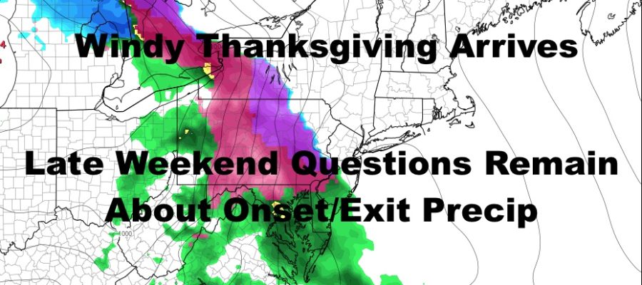
Our next system will arrive via the Great Lakes, with moisture well out ahead of a broad low pressure system. As that moisture hits our shallow layer of cold air, we could see precipitation start out as a period of snow, sleet, or mix. Depending on how stubborn that cold air is, will dictate as to how long this period of frozen or mixed precip lasts, if it happens at all.
Regardless, we go over to a cold rain and this will not be a major event for the NYC/Long Island area. Expect that steady cold rain Sunday afternoon into Monday morning, then showery conditions for the rest of Monday. Look for highs in the low 40’s both Sunday and Monday, and raw, chilly conditions overall.
As our secondary low pressure spools up and departs, we could see some more frozen precip or mix on the back end with colder air filtering into all levels of the atmosphere. However, most of the action will be concentrated in NE New England with precip already beginning to wind down here; making anything that does happen, light in nature.
LOCAL RADAR PHILADELPHIA


MANY THANKS TO TROPICAL TIDBITS FOR THE USE OF MAPS
Please note that with regards to any tropical storms or hurricanes, should a storm be threatening, please consult your local National Weather Service office or your local government officials about what action you should be taking to protect life and property.