OMNITRUEVALUE.COM

WEATHER IN 5/JOE & JOE WEATHER SHOW PODCASTS
Northeast To Get Walloped By Wide Swath Of Heavy Snow
Good morning everyone. We have a lot going on and still some tweaking to be done forecast-wise, but it’s obvious to most that the Northeast is in for a rough ride tomorrow evening into Thursday morning. Cold air is locking in as we speak, and a strong area of low pressure in the form of a Nor’Easter, will slam into that airmass, creating a large area of very heavy snow we haven’t seen in a couple of years.
SATELLITE

Today we remain sunny, breezy, and chilly, with highs in the upper 30’s to near 40. Overnight, we dip into the low to mid 20’s, and that helps us set up the scenario for late tomorrow.
REGIONAL RADAR

We’ll cloud up tomorrow, and temps won’t recover much with highs in the low to mid 30’s. Expect light snow to begin some time late afternoon into evening, then pick up in intensity as we go on.
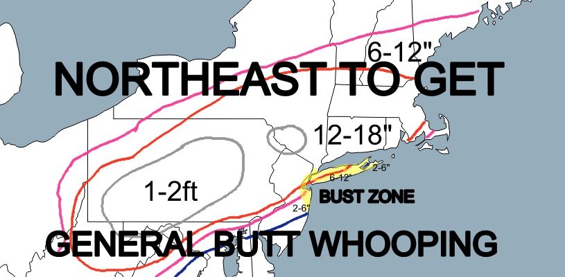
SNOWFALL MAP

I don’t think we’ll have much adjusting to do here aside from where the heaviest bands set up. It is impossible in a storm like this to predict what the radar is going to look like and where banding will happen. Also a feature many don’t add, is the “bust zone”. This is an area I’ll be watching to see if any warmer air creeps in, any dry slots form, affecting final totals.
Right now, the south shore of Long Island, its Forks, and the NJ Shore is at the biggest risk of seeing some complications. However, a general 6-12″ is expected along the south shore of LI and 2-6″ on the extreme Forks as of now.
Again, we can adjust as things unfold. The “Bust Zone” is not only at risk for a downside surprise, but an upside surprise as well. If we get no mixing and/or no dry air, the entire area will see a general 12-18″ ass kicking.
The heaviest action will be overnight tomorrow into Thursday AM, then things will begin to taper off. Expect a cold and windy Thursday, with late sunshine, but highs only near 30.
MANY THANKS TO TROPICAL TIDBITS FOR THE USE OF MAPS
Please note that with regards to any tropical storms or hurricanes, should a storm be threatening, please consult your local National Weather Service office or your local government officials about what action you should be taking to protect life and property.