NYC Accumulating Snow Chance Fading Away
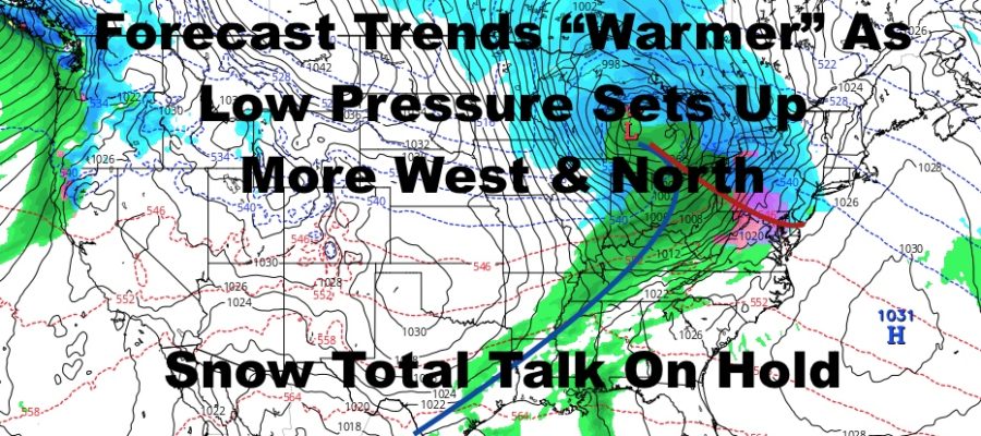
Good morning everyone. We have a beautiful and mild day today before our forecast grows colder and more complicated. If you’ve been following the forecasts since we started talking about our next big system, I stated that timing and path will be key. Some of my “concerns” are coming to fruition as precipitation looks to start later in the time frame Saturday, and low pressure wants to set up too far west and north; cutting down any prolonged frozen precip for much of the area.
SATELLITE

For today, the forecast is as simple as it it gets. Look for sunny skies, mild conditions, light winds, and highs in the upper 40’s to low 50’s.
Clouds increase tonight ahead of our much colder air and pattern change coming in, and we’ll see the chance of some rain late.
REGIONAL RADAR

Tomorrow, we’ll have the slight chance of an AM shower, then decreasing clouds and increasing winds. Highs will be in the mid 40’s, but expect a sharp drop as sunset arrives. Overnight, lows will head down into the low to mid 20’s, and some teens will be possible N&W of NYC.
Friday remains looking cold and breezy with highs barely reaching 30, then upper teens to low 20’s overnight.
LOCAL RADAR NEW YORK CITY

Clouds increase Saturday morning with our next system coming in. As of now, precipitation starting early to mid afternoon will be a detriment to snow lovers, plus low pressure further to our west will trend the atmosphere slightly “warmer”. This will equate to the chance of a more brief period of snow or period of mixed precip, before we go to rain by evening. Highs Saturday will be near 40 (we could go slightly warmer), and the late start/brief period of frozen period will result in hardly any accumulation (if anything at all).
We’ll hold off on accumulation talk, but areas N&W of the NYC area, Pennsylvania, and NJ, will also see accumulations cut down as well.
LOCAL RADAR PHILADELPHIA


Regardless of what happens Saturday, we clear out on Sunday after the slight chance of some early AM rain, then much colder air heads in the start the week. As of now, our pattern changes to a colder one, with systems digging further into the south, but no major snowfall for the NYC area is on the immediate horizon.
We’ll continue to watch.
MANY THANKS TO TROPICAL TIDBITS FOR THE USE OF MAPS
Please note that with regards to any tropical storms or hurricanes, should a storm be threatening, please consult your local National Weather Service office or your local government officials about what action you should be taking to protect life and property.