DOWNLOAD MY NEW FREE JOESTRADAMUS WEATHER APP FOR ANDROID
THE APP IS ABSOLUTELY FREE TO ALL BUT CONSIDERING SUBSCRIBING TO PATREON FOR A WEATHER EXPERIENCE FREE OF ADS, EXCLUSIVE VIDEOS FOR MEMBERS ONLY AND MUCH MORE…STARTS AT $2 A MONTH..MESSAGE ME AT ANY TIME
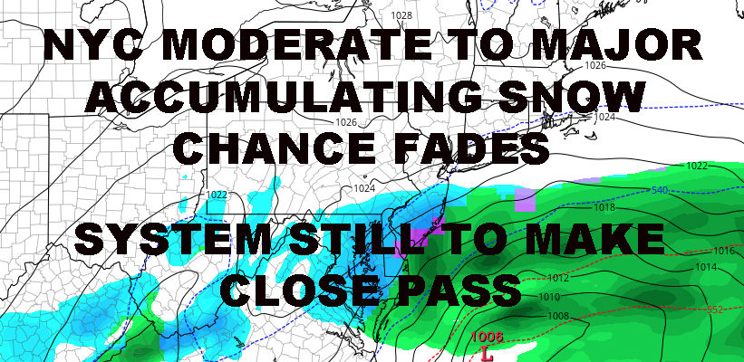
NYC BIG SNOW CHANCE FADES AS STORM MAY SLIGHTLY GRAZE AREA
Good morning everyone. Snow lovers, get out the bugle and start playing Taps for our system as things won’t work out this time for the NYC area. Meanwhile, cold air is here even though it won’t mean much to some due to their overwhelming disappointment.
EASTERN SATELLITE

Expect a windy and seasonably cold day, highs in the low to mid 30’s and wind chills in the teens at times. The wind continues tonight as we drop into the upper teens to low 20’s.
Tomorrow will be the coldest day we’ve had in a while with highs in the 25-30 degree range. Winds won’t be as gusty, but it’ll remain steady in the 15-20mph realm. Tomorrow night is looking very cold, with lows in the NYC area in the upper teens. Away from NYC, we could see some low to mid teens.
REGIONAL RADAR

On Saturday, clouds will increase as our much-talked-about system nears; highs in the upper 20’s to low 30’s. Well ahead of it, we could see some light snow developing late as some overrunning occurs. While this is associated with the system, it wouldn’t be snow from the low pressure expecting to strengthen off the coast of the Mid-Atlantic.
There are still some questions that remain in terms of how close the precip shield gets to our area, but we do know a few things. First, low pressure will be fast moving and it will not be a powerful system, regardless of who gets hit. Areas of DE, VA, MD, and Southern NJ, could see a narrow 5-10″ band of snow. Also, with things not being overall impressive strength-wise, it’ll be easier for dry air to win out.
So for now, we’ll be on the lookout for low pressure going south of the area and scooting out to sea. Eyes will be on how far north that precip shield gets, but even if it does brush the area, a brushing it’ll be and snow will remain fairly light.
Our best chance of snow remains to be Saturday night with that overrunning action, but we have to see if even that materializes and dry air doesn’t completely win out. If we do get some light snow, it’ll certainly be cold enough to stick, so we’ll be watching things to see if we can squeeze out a dusting or more.
If snow does make it in, everything departs on early on Sunday and it’ll be cloudy, cold, and windy. Highs in the upper 20’s to low 30’s.
LOCAL RADAR NEW YORK CITY

As discussed yesterday, we have several chances of very cold air, but that cold air is transient and each blast should be brief in nature as we waiver between very cold and average. Our pattern in terms of system path is changing as well.
For the past couple of months, low pressure has been going well north and well west of the area. Now it’s looking to shift between just west and just south of the area. This means we’ll have to watch each system for the chance of rain, snow changing to rain, all snow, or near-misses like this weekend.
LOCAL RADAR PHILADELPHIA


MANY THANKS TO TROPICAL TIDBITS FOR THE USE OF MAPS
Please note that with regards to any tropical storms or hurricanes, should a storm be threatening, please consult your local National Weather Service office or your local government officials about what action you should be taking to protect life and property.