DOWNLOAD MY NEW FREE JOESTRADAMUS WEATHER APP FOR ANDROID
THE APP IS ABSOLUTELY FREE TO ALL BUT CONSIDERING SUBSCRIBING TO PATREON FOR A WEATHER EXPERIENCE FREE OF ADS, EXCLUSIVE VIDEOS FOR MEMBERS ONLY AND MUCH MORE…STARTS AT $2 A MONTH..MESSAGE ME AT ANY TIME
NYC WIND COLD ARRIVES WEEKEND SYSTEM CONTINUES TO LURK
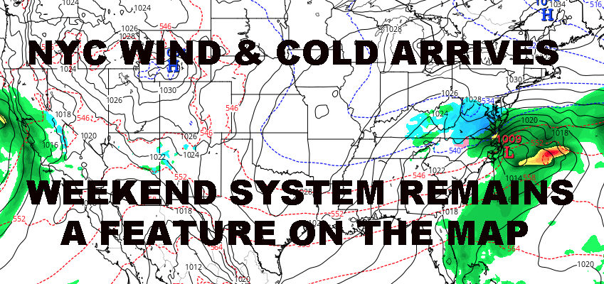
Good morning everyone. Cold air is starting to filter into the area and it’ll be bringing some nasty wind with it. Plus, models at this time are not showing a hit for the Northeast this weekend snow-wise, but a storm continues to remain a feature on the map and it must be watched due to its close proximity.
EASTERN SATELLITE
For those waking up early, you’ll be doing so to our high temps for the day. We have upper 30’s to low 40’s in most of the area and those numbers will be dropping as the day goes on. Expect 15-25mph sustained westerlies, with gusts to near or just above 40mph.
The wind continues to roar overnight tonight as we drop into the mid to upper 20’s, and it even continues into tomorrow as we average out in the low to mid 30’s.
REGIONAL RADAR
The real cold stuff moves in for Friday as we find ourselves in the 25-30 degree range and a steady breeze continuing, then upper teens to low 20’s as lows overnight. Areas N&W of NYC and the Long Island area will definitely see some teens overnight Friday.
LOCAL RADAR NEW YORK CITY
The weekend remains in question but Saturday remains an easy forecast. Expect cold air to continue its hold, with upper 20’s to low 30’s. Unless anything changes with the path of our system, we could get a brushing of very light snow overnight Saturday in Sunday if the precip shield can edge up into our area briefly.
Otherwise, all indicators as of this moment point to a system slipping just south of us and quickly heading out to sea. We’ll continue to keep an eye on everything because due to its close proximity and it being only Wednesday, we could wake up tomorrow or Friday and things could change.
In the end though, our low pressure may be moisture-laden, but it doesn’t look very powerful; increasing the chance that high pressure wins out on this whole deal. It simply won’t have enough torque to nudge into the area if high pressure digs in early and deep, and that’s the issue we’re looking at – the timing/strength of the high vs strength of the low.
LOCAL RADAR PHILADELPHIA

In the long range beyond this, colder than average air will be transient, with brief periods of very cold air vs. periods of near average temps. Systems continue to march west via the Pacific, but it’s too early to tell what lies beyond this weekend as far as any snow-friendly systems.
MANY THANKS TO TROPICAL TIDBITS FOR THE USE OF MAPS
Please note that with regards to any tropical storms or hurricanes, should a storm be threatening, please consult your local National Weather Service office or your local government officials about what action you should be taking to protect life and property.


