
Weather in 5/Joe & Joe Weather Show Latest Podcast
NYC Big Storm Brings Wide Range of Conditions
Good morning everyone. We continue to watch everything come together as far as a cold airmass lining up, and two pieces of energy combining before heading up the I95 corridor. This will bring a wide range of conditions, even in the NYC/Long Island area.
SATELLITE

Look for mostly skies this morning, then increasing clouds as the day goes on. We’ll have highs in the near 50/low 50 range for a nice seasonable, “calm before the storm” type day. Clouds will lower and thicken tonight, and we should have some steady rain developing before sunrise. There is no risk of frozen precip overnight as temps only drop into the mid 40’s.
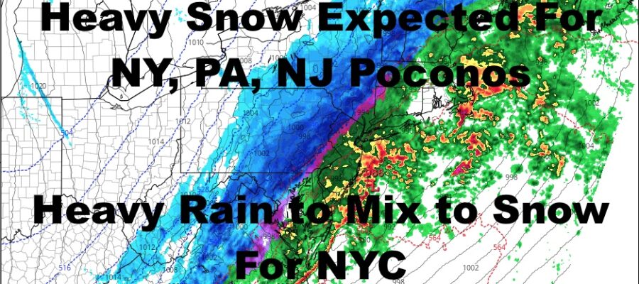
WEATHER RADAR

For tomorrow, we’ll have rain, heavy at times, with possibly even a rumble of thunder. I’m looking for rain to mix with some wet snow and/or sleet some time between 11am and 1pm, then we will slowly change everything over to snow. This will be a wet snow falling on wet ground, then a drier snow just before things end. At best I think we whiten colder surfaces in the NY/LI area, with a coating to 2″ possible. It’ll also be blustery and raw throughout this whole thing, with winds gusting in the 35-40mph range.
Lows overnight tomorrow will be a big problem, with a flash freeze possible as temps dip to the low 20’s. Anything wet will turn into a sheet of ice, causing dangerous driving conditions overnight tomorrow.
For the Poconos of NY, NJ, and PA, this is a different animal. Expect rain changing to snow a lot faster, heavy at times, with 6-12″+ possible. The heaviest snow will be in the Poconos, but for NY, 6″+ is still possible from about Peekskill on northward.
We remain cold and blustery for Sunday. Look for sunshine and highs in the upper 30’s. This will help melt the ice, but it’ll be a cold day for March 13th.

We modify things very quickly, with sunshine for part of the week and mid 50’s for Monday; then highs near 60 Tuesday & Wednesday. I’m holding off on Thursday because we may get brushed by a system with some clouds and light rain. If not, we might get to near 60 again.
BE SURE TO DOWNLOAD THE FREE METEOROLOGIST JOE CIOFFI WEATHER APP &
ANGRY BEN’S FREE WEATHER APP “THE ANGRY WEATHERMAN!

MANY THANKS TO TROPICAL TIDBITS & F5 WEATHER FOR THE USE OF MAPS
Please note that with regards to any severe weather, tropical storms, or hurricanes, should a storm be threatening, please consult your local National Weather Service office or your local government officials about what action you should be taking to protect life and property.