NYC Cloudy Cooler Day Today Long Range Interesting
Good morning everyone. We have a cloudy and cooler day today compared to yesterday, but the humidity sticks around as does the prospect for a few rumbles. Overall, we tumble into the mish-mosh of cloudier, cooler, and sometimes wetter stretch, from the hot, dry, and steamy weather we’ve had since June. Further down the road this month, we may even get a brief taste of some cool, dry, Canadian air.
SATELLITE

Expect clouds to stick around today with a humid low to mid 80’s for highs. Same as yesterday, we’ll have the chance of some pop up showers and storms. Most of the action will be just inland again, but we’ll be watching to see what drifts our way or grows outward. Best chance to see storms in the NYC/Long Island area, will once again be Manhattan, the Bronx, and interior parts of Long Island.
REGIONAL RADAR

Tomorrow we rinse and repeat, with a humid low to mid 80’s, generally mostly cloudy skies, and the slight chance of some showers and storms.
LOCAL RADAR NEW YORK CITY

Saturday looks to be the better day of the weekend as maritime high pressure temporarily dominates just enough to get some sun in the area. Look for a mix of sun and clouds, a stiff easterly flow, and highs in the near 80 to low 80 realm.
We’ll have more clouds than Sun on Sunday, and some showers may pay a visit. Highs Sunday will be on the relatively/seasonably cool side, with upper 70’s to near 80.
LOCAL RADAR PHILADELPHIA


This pattern wants to stick around for a little while with the east coast being a little troughy, with maritime high pressure wanting to fight back. That puts us in a squeeze play between clouds and scattered showers, then a few more sunnier days with temps ranging from the upper 70’s to mid 80’s depending on the wind profile.
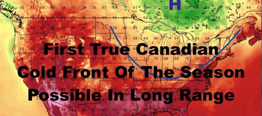
No 90’s are in the immediate future for the NYC area. However, if a pretty significant Canadian cold front is able to enter the Country, we could see some more hot & humid weather ahead of it before a major cool-off. We are talking 10+ days away for that scenario and things could easily fizzle out and change. If that’s the case and this cold front never materializes, we could see a gradual shift back to hotter and drier weather overall.
Let’s see how this all plays out.
MANY THANKS TO TROPICAL TIDBITS FOR THE USE OF MAPS
Please note that with regards to any tropical storms or hurricanes, should a storm be threatening, please consult your local National Weather Service office or your local government officials about what action you should be taking to protect life and property.