NYC Coastal Storm Chance Increasing
Good morning everyone. We continue to enjoy a quiet week with a chill in the air, but we’re also watching the models very closely for a possible coastal storm that will try to develop as we get into the weekend.
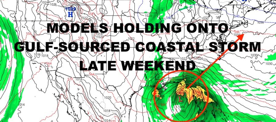
All of the ingredients are there in terms of energy coming out of the Rockies, diving southeast into the lower Plains, and our stalled front near the Florida Keys. As of now, we’re expecting that stationary front begin to return as a warm front into the Gulf of Mexico. If a wave of low pressure is able to form along this front, the energy coming out of the Rockies may phase with it, then move up the coast as our chilly high pressure departs.
Again, this is not a snow event for the East Coast if the ingredients come together. Gulf-sourced systems are generally warm in nature, and in order to get a dumping of snow out of these, you really need that January/February biting cold to make things work. This will primarily be a rain, wind, and flooding event if it comes to fruition.
There are some slight complications though if the low gets cut off and is allowed to meander for an extra day or two. The primary concern would be coastal flooding due to a prolonged ESE/ENE wind. The secondary concern would be if low pressure is powerful enough and sticks around, it could pull in some cold air from Canada and give some areas a rain-changing-to-mix or ice scenario. Some of the models depict this, but the human aspect sets off a red flag on this, and it’s simply too early to predict such a dynamic setup.
For now, we will watch everything closely and take you to Sunday on the forecast…
SATELLITE

For today, we have a sunny and chilly one with light winds. Look for highs in the low to mid 40’s. Overnight will be a cold one, with 25-30 degree temps for lows.
WEATHER RADAR

Tomorrow is the coldest day of the bunch before we modify. Expect sunshine and lights winds, highs in the upper 30’s to near 40. Things modify fast on Friday, with more sunshine and highs in the near 50/low 50 realm.

Look for sun and clouds on Saturday with more low 50’s, then becoming cloudy on Sunday with upper 40’s to low 50’s. The timeframe for this system IF it materializes looks to be Sunday night onward in terms of rain and developing wind. We’ll also have to see when it departs as impacts from the system could last into Wednesday.
BE SURE TO DOWNLOAD THE FREE METEOROLOGIST JOE CIOFFI WEATHER APP &
ANGRY BEN’S FREE WEATHER APP “THE ANGRY WEATHERMAN!
MANY THANKS TO TROPICAL TIDBITS & F5 WEATHER FOR THE USE OF MAPS
Please note that with regards to any severe weather, tropical storms, or hurricanes, should a storm be threatening, please consult your local National Weather Service office or your local government officials about what action you should be taking to protect life and property.