
COUPON CODE SUMMER24 GET 10% OFF
(Tempest is an affilllate of Meteorologist Joe Cioffi & earns commissions on sales.)
NYC Easier Workweek Ahead
Good morning everyone. We have a weak disturbance passing by this morning and early afternoon; bringing with it, some wet snow, mixed precipitation, and rain. This is nothing of consequence for those who see all snow, as it’ll add a dusting to a 1/2″ of snow on top of areas already covered with snow. The workweek is the big story since things ease up a bit in terms of deep-winter conditions. Look for milder conditions, but some rain and onset mixed precipitation at times.
As far as the very mild temps predicted by the weather grifters on social media, I don’t think it plays out well for the NYC and Long Island area. Maritime air is going to push back hard, and 70’s will probably be very elusive unless you live in areas such as central PA.
SATELLITE

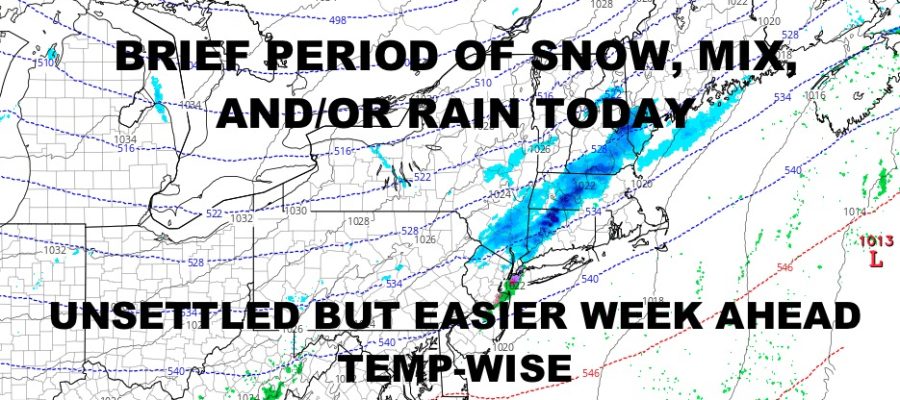
For today, look for morning to early afternoon snow, mixed precipitation, and/or rain. Areas across the south shore of Long Island could stay all rain or mixed precipitation; wheres the north shore of Long Island could see some snow out of it. Temps are above freezing, so anything that does fall will only accumulate on already-fallen snow. Highs today will be where they’re at in the mid to upper 30’s.
WEATHER RADAR

Behind our disturbance is some brief colder air. It’ll be a sunny one tomorrow, but highs only reach into the upper 20’s to low 30’s. Things modify a bit on Tuesday, but not before some onset snow or mixed precipitation changing to rain. Highs in the upper 30’s to low 40’s. Clouds stick around on Wednesday, with the chance of a few scattered showers and highs in the mid to upper 40’s. Modification continues on Thursday, with more widely scattered showers and mid to upper 50’s. We’ll take a step back on Friday with morning scattered showers and highs in the 45-50 range.

Saturday will feel like spring compared to the temps we’ve had. Look for sunshine and highs 55-60. Rain will most likely move through Saturday night ahead of our next front, and Sunday looks breezy and seasonable with 50-55 degree temps.
BE SURE TO DOWNLOAD THE FREE METEOROLOGIST JOE CIOFFI WEATHER APP &
ANGRY BEN’S FREE WEATHER APP “THE ANGRY WEATHERMAN!
MANY THANKS TO TROPICAL TIDBITS FOR THE USE OF MAPS
Please note that with regards to any severe weather, tropical storms, or hurricanes, should a storm be threatening, please consult your local National Weather Service office or your local government officials about what action you should be taking to protect life and property.