NYC Extra Clouds Better Rain Chance Tomorrow
Good morning. Today is looking pretty solid with high pressure still the dominant (but fleeting) feature on the map. However, we’re fine-tuning tomorrow which wasn’t unexpected as I said highs were sunshine-defendant, and we had to see where the energy sets up.
SATELLITE

Expect another beautiful and breezy day today, slightly warmer, with highs in the 80-85 realm (slightly cooler at the immediate shore).
For this evening/ tonight, clouds increase early due to the front being closer in proximity and the energy feed beginning to drape down over us.
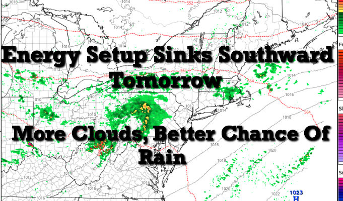
Look for clouds to dominate tomorrow with some peeks of sun here and there. We’ll still be on the “right” side of the front, but it’ll be too close to eek out a nice day overall. We’ll have the chance of showers at any time throughout the day; not a washout, but know you can see some passing showers; warm and humid, highs in the upper 70’s to low 80’s. IF some spots happen to see some extra sunshine, mid 80’s could break out.
As our day rolls on, we’ll add thunderstorms into that shower chance, especially in the evening, onward. Some of those storms could be strong to severe in nature.
REGIONAL RADAR

As stated yesterday, we’ll rinse and repeat for Monday, but Monday has the potential to be warmer and even more humid. Timing of precip is on hold for now as we take things day to day once again to see the final setup.
LOCAL RADAR NEW YORK CITY

Tuesday onward, it looks as if we remain unsettled the entire week. I don’t think we see any full washouts, but we will see waves of precip move in and out of the region each day and/or night.
When this happens, we take each day at a time to ensure the utmost accuracy in both precip and high temp categories.
Stay tuned.
LOCAL RADAR PHILADELPHIA


MANY THANKS TO TROPICAL TIDBITS FOR THE USE OF MAPS
Please note that with regards to any tropical storms or hurricanes, should a storm be threatening, please consult your local National Weather Service office or your local government officials about what action you should be taking to protect life and property.