NYC Intermittent Tropical Showers & Storms Tomorrow
Good morning everyone. We have another hot and humid one today as we approach or break 90 once again; then our eyes turn to the Mid-Atlantic with a tropical/subtropical low heading up into our region.
SATELLITE

Overall we have a fairly nice day today that’ll be thunderstorm-free, but it’ll be another hot and humid one. Expect highs in the upper 80’s to low 90’s, and the best chance to see those 90+ temps will be in downtown Brooklyn and Central Queens.
REGIONAL RADAR

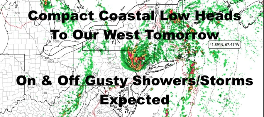
Our much expected low pressure system will visit the area tomorrow, and all models point to it heading inland, just west of the NYC area.
What does that mean for us? Expect our area to be visited by the rain bands forming to the east of that compact low pressure system. That’ll equate to on and off gusty heavy showers and storms. Localized flooding in poor drainage areas is possible, but the biggest flooding concern will be in parts of NE PA and NW NJ as the most concentrated area of precipitation will move over those areas.
Also, as these rain bands form and head in from off of the ocean, we could see some waterspouts along the south shore of Queens & Long Island, as well as the LI Sound. Highs will be a humid low 80’s with a steady easterly fetch.
LOCAL RADAR NEW YORK CITY

For Saturday, some moisture sticks around as low pressure departs, and the front that helped bring it up the coast, will sweep across the area. That’ll help spark some scattered afternoon storms, and we’ll get back into the upper 80 to near 90 conditions.
Sunday we dry out a little more, but still keep the slight chance of a PM storm. It’ll be hot & humid and we’ll see more near 90 to low 90 weather.
LOCAL RADAR PHILADELPHIA


Next week remains looking very warm to hot, and we continue to watch the prospect of a heatwave or near-heatwave conditions potentially starting next Thursday or Friday.
Stay Tuned.
MANY THANKS TO TROPICAL TIDBITS FOR THE USE OF MAPS
Please note that with regards to any tropical storms or hurricanes, should a storm be threatening, please consult your local National Weather Service office or your local government officials about what action you should be taking to protect life and property.