DOWNLOAD MY NEW FREE JOESTRADAMUS WEATHER APP FOR ALL DEVICES
THE APP IS ABSOLUTELY FREE TO ALL BUT CONSIDERING SUBSCRIBING TO PATREON FOR A WEATHER EXPERIENCE FREE OF ADS, EXCLUSIVE VIDEOS FOR MEMBERS ONLY AND MUCH MORE…STARTS AT $2 A MONTH..MESSAGE ME AT ANY TIME
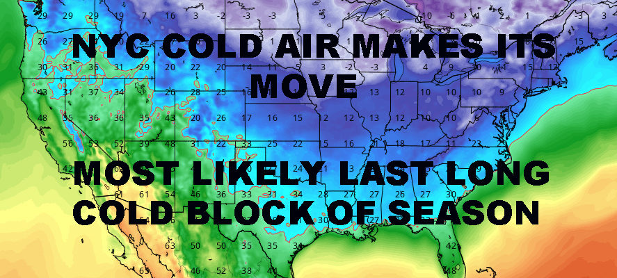
NYC LAST GASPS OF DEEP WINTER IN PLAY
Good morning folks! As expected, very cold air has invaded the Northeast and NYC area behind the system that brought mixed precipitation and snow here, and all snow for interior parts. We’re entering the last throws of winter now, where excitement builds for Spring, and brief setbacks occur here and there. Brief will be the key word here for those who listen carefully and understand how the gears turn toward April and May.
EASTERN SATELLITE

First off, lets deal with that cold air in our area right now. Sunny skies and light westerlies dominate today with highs in the upper 20’s to low 30’s. That’ll put us at 10-15 degrees below normal in most areas this time of year, but it’s nothing we’re not used to. While we’ve been relatively light in the snow department this season, it hasn’t been a particularly warm winter.
Overnight, things get windy and very cold. Expect the wind to keep full radiational cooling from happening, but clear skies will still allow temps to drop into the the mid to upper teens in the NYC area. Away from NYC proper, we could see some low teens; or even single digits well away from the City.
REGIONAL RADAR

Tomorrow, we cloud up a bit as a very weak disturbance skips across the great lakes. This will be the coldest day of March in my opinion as we may not get out of the 20’s, and if we do, it may only be by a degree or two.
Clouds will help us from falling into the mid teens tomorrow night, but we could see some widely scattered flurries as that disturbance slowly moves on by.
We’ll clear out by mid-Thursday, but remain very cold for this time of year; highs in the upper 20’s to low 30’s.
LOCAL RADAR NEW YORK CITY

We’ll modify slightly on Friday as another weak system looks to slide south of us this time, but still remain below normal; highs in the mid to upper 30’s. Look for the slight chance of some light snow overnight Friday IF that system is able to eek out a northerly jog and beat out the very dry air. Either way, it’ll be nothing of consequence.
Your weekend looks like a split as we start to climb out of the basement cold-wise. Expect sun and clouds Saturday with highs in the low to mid 40’s, then we watch for a fairly vigorous system on Sunday. For those looking or hoping for more snow, this looks like no dice with a very familiar pacific-influenced track. So far we’re looking at rain late on Sunday with highs in the upper 40’s to low 50’s.
LOCAL RADAR PHILADELPHIA


In the long range, we’re looking at things breaking up cold-wise, but remain active as expected. We’re back to a familiar pattern that for the most part, could take us into April.
Now read carefully. This doesn’t mean we can’t have a cold day or two. This doesn’t meant we can’t see a few flakes left. This also doesn’t mean I’m calling for 70’s and a big Spring bust-out. What I do see is the end to week-long blocks of very cold weather like we will experience this week. Aside from front-related mild air ahead of anything that goes well north and west of us, I think we return to more seasonal temps while our active and rainy pattern continues.
This is also the time of year where we have to start watching the Gulf very closely. Fronts moving across the Nation like to tap the Gulf this time of year (think of the severe weather Alabama just had) and sometimes we get a wave of low pressure that forms. Timed correctly, and mid-March to early April is ripe for ass-kicking, Gulf-inspired, Nor’easters or inland monsters.
We will keep an eye on all of the features during this notoriously busy time of season, but at least we get rid of these week-long cold shots after this period.
MANY THANKS TO TROPICAL TIDBITS FOR THE USE OF MAPS
Please note that with regards to any tropical storms or hurricanes, should a storm be threatening, please consult your local National Weather Service office or your local government officials about what action you should be taking to protect life and property.