
DOWNLOAD MY NEW FREE JOESTRADAMUS WEATHER APP FOR ALL DEVICES
THE APP IS ABSOLUTELY FREE TO ALL BUT CONSIDERING SUBSCRIBING TO PATREON FOR A WEATHER EXPERIENCE FREE OF ADS, EXCLUSIVE VIDEOS FOR MEMBERS ONLY AND MUCH MORE…STARTS AT $2 A MONTH..MESSAGE ME AT ANY TIME
NYC WINTER STORM WARNINGS ISSUED FOR MARCH SNOW
Good morning everyone. Clouds never really got a chance to leave with system after system, so clouds remain here in the NYC area while we await our 4th and heaviest round of snow from the final system of this parade. Winter Storm Warnings have been issued for a quick-moving system that’ll dump a moderate amount of snow for most of the area.
EASTERN SATELLITE

Once again, we find ourselves starting off with rain as this will not be an all-snow system. This and speed, will be a factor in saving us from much higher amounts of snow when things do change over. Expect the chance of some afternoon light rain today, highs in the low 40’s.
Look for rain to change to snow some time between evening and midnight, then come down with some good intensity. It’ll have to come down hard and fast to cover the ground and circumvent the wet surfaces, but we expect that to happen once things really get going. How fast the process takes, will dictate whether we are on the lower end of the spectrum, or higher end.
Final Call Snow Map – Issues remain for parts of Long Island
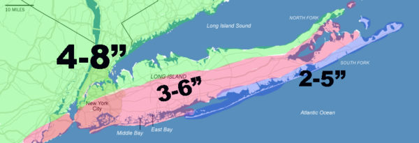
The final snow map has been tweaked and honed-in properly to reflect what is going on; taking into account that things may begin to stick a little faster in the northern areas of NYC and Long Island, including Manhattan, the Bronx, downtown Brooklyn, northern Queens, and even parts of Staten Island.
Instead of saying “3-6+’, I gave this general area a 4-8″ swath and kept a general 3-6” area through parts of Staten Island, central and southern Brooklyn, Central and Southern Queens, and central parts of Long Island/south shore of Nassau County.
However, the rain/snow line is still very close to Long Island and remember, we still start out as rain. It’s very possible precipitation-types could go through cycles for parts of Long Island, holding accumulations down. For now, this reflects the south shore as you go east, but we’ll have to keep a close eye on the radar and proximity of that rain/snow line once things begin to try and change over and/or as intensity increases.
This remains a complicated forecast, and there is potential for BOTH bust AND an upside surprise in areas with less accumulation depicted. Everything hangs on when that changeover occurs, how quickly it sticks, and if there is any mixing beyond the initial onset.
Believe me when I say, I’m not hedging my bets, I’m just telling it like it is. The snow map is final and up, but there is potential for some error in either direction.
REGIONAL RADAR

Everything is gone early tomorrow, possibly even before sunrise, then partial clearing will ensue. Expect steady northwesterlies and highs in the upper 30’s to near 40. My suggestion is, clean up and clear as much as you can so exposed areas of pavement can fully melt the thin layer of snow/ice shovels never get; and give things a chance to dry out before everything freezes overnight.
Temps overnight tomorrow will dip into the upper teens to low 20’s, so I can assure you, things will freeze fast and get slippery/crunchy.
LOCAL RADAR NEW YORK CITY

The rest of the week continues to look unseasonably cold, with highs in the low to mid 30’s Tuesday, then 20’s for Wednesday, and barely 30 on Thursday. Teens will rule overnight before we begin to slowly modify at the end of the week with our next system.
LOCAL RADAR PHILADELPHIA


MANY THANKS TO TROPICAL TIDBITS FOR THE USE OF MAPS
Please note that with regards to any tropical storms or hurricanes, should a storm be threatening, please consult your local National Weather Service office or your local government officials about what action you should be taking to protect life and property.