NYC Major Storm Brings Wide Range Severe Conditions
Good morning everyone. We have one more quiet day today before the storm clouds gather tomorrow, with a major storm bringing with a wide array of severe weather conditions. As I’ve said before, regardless of the precip type for NYC and Long Island, this is going to be one ass-kicking storm; leaving some asking themselves when this is over, “what the hell was that??”.
SATELLITE

Sunshine mixed with some clouds today will combine with chilly temps and light winds to give us that “calm before the storm” feel. Expect highs in the 35-40 range, then clouds increase overnight to give us thermal-blanket-lows in the near 30 range. Still cold, but not compared to what’s coming.
WEATHER RADAR

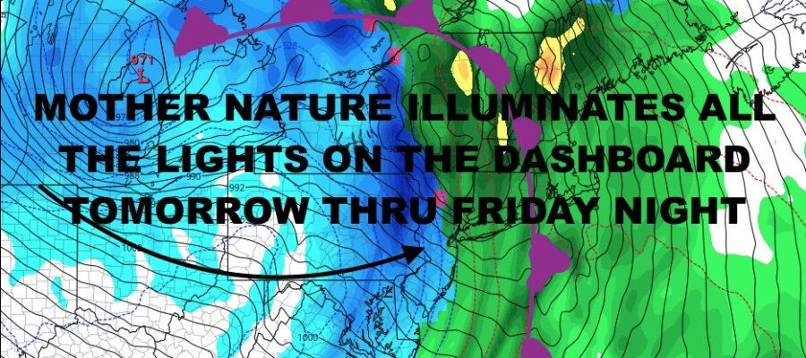
Clouds lower and thicken tomorrow, with maybe a few fast moving, widely scattered showers developing by late morning. However, the steady rain holds off till late afternoon/early evening. Highs will be in the mid 50’s, so anything that does fall will be rain. Winds increase overnight as does the intensity of the rain. Easterly winds will become ESE, then SSE as we heads towards the pre-sunrise hours. Winds will gust between 45-55 mph, and we could see even stronger gusts along the immediate shore and Forks of Long Island. Moderate to major coastal flooding is likely in flood prone areas, so take action to protect property. If you get flooding during a Nor’Easter, treat this no different and even approach it with more caution. Flooding will occur during the high tide cycles of overnight tomorrow and Friday.
Damaging winds will continue Friday, possibly doing even more damage as winds swing around to the west. Heavy rain and possibly some thunder, could as as a burst of heavy snow as temps drop through the 40’s and will be in the 20’s by late afternoon. Flash freezing will cause black ice, large ice patches where standing water was, and create treacherous driving conditions for Friday evening rush our. Depending on the final setup with the moisture racing against the cold air, if a burst of snow does happen, we could see a coating to an inch or more (depending on the intensity). Lows overnight Friday will be in the 10-15 degree range.
Again, for those traveling, travel today if possible. Airports will be impacted tomorrow even though our system isn’t hitting the NYC area till later in the day. Other areas of the Country will begin to feel the impact, causing cascading delays and cancellations earlier than the storm’s arrival to NYC.

Christmas weekend remains very dry, sunny, and unseasonably cold. Expect highs in the low to mid 20’s Saturday, mid to upper 20’s Sunday, and lows in the 12-18 range both nights.
BE SURE TO DOWNLOAD THE FREE METEOROLOGIST JOE CIOFFI WEATHER APP &
ANGRY BEN’S FREE WEATHER APP “THE ANGRY WEATHERMAN!
MANY THANKS TO TROPICAL TIDBITS & F5 WEATHER FOR THE USE OF MAPS
Please note that with regards to any severe weather, tropical storms, or hurricanes, should a storm be threatening, please consult your local National Weather Service office or your local government officials about what action you should be taking to protect life and property.