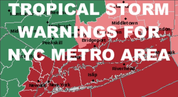
NYC Metro Area Tropical Storm Warnings Posted
Good morning everyone. Tropical Storm Isaias is now picking up steam and beginning its move towards the Carolinas, then flying through the Northeast. It’ll be moving fast enough to just hold onto Tropical Storm status when it gets in our backyard, hence, tropical storms warnings have been posted.
SATELLITE

Today will be the “calm before the storm”, and we have a hot one ahead. Expect clouds and sun, muggy conditions, and highs in the low 90’s. We’ll also have a steady breeze today and the slight chance for a few storms.
REGIONAL RADAR

Tomorrow is the day as Isaias will pay a visit. Rain will start well before the tropical storm gets here as it enhances the front that’s steering it up the coast. Winds will begin to increase beyond the steady breeze, and we should have the effects of Isaias coming through from 4pm onward.
As far as winds are concerned, the sustained winds should be in the realm of tropical depression level, but the winds gusts will reach tropical storm force. On average, we should see 2-4″ of rain, with the highest amounts just to our west. Remember, this is a fast mover, so it won’t have much time to match or exceed systems in the past.
Tides will be an issue for 1 cycle, which will be the high tide that occurs late tomorrow evening/night. Expect minor to moderate coastal flooding, similar to a strong Nor’easter. We won’t have a destructive and dangerous surge, but those areas that flood during a strong Nor’easter in conjunction with the full moon, need to take note.
This equates to areas such as Far Rockaway along Seagirt Blvd, Broad Channel, Long Beach on the canals & bay side of the state streets, Freeport, Baldwin, Lindenhurst, and other areas which flood more frequently, need to take steps to protect property. Get your cars away from the bulkheads, make sure your sump pumps are operational, and heed the warnings/instructions from your local administrators.
LOCAL RADAR NEW YORK CITY

Things improve very quickly on Wednesday, with departing early AM showers, full late morning sunshine, and highs possibly near 90 again.
Thursday and Friday look “pleasant” compared to the heat we’ve been having, with sunshine and mid 80’s. However, the heat returns for the weekend, and upper 80’s to near 90 temps will be with us once again under sunny skies & dry conditions.
LOCAL RADAR PHILADELPHIA


In the long range, Isaias may have opened us up for a very hot August, which is something I explained when things just got going last week. We still have 2 possible heatwaves ahead of us, one expected, and the other a concept idea. We’ll be looking for low 90’s+ to return some time next week, then a little bit of a “break” (mid 80’s) before hot weather returns possibly mid-August onward.
MANY THANKS TO TROPICAL TIDBITS FOR THE USE OF MAPS
Please note that with regards to any tropical storms or hurricanes, should a storm be threatening, please consult your local National Weather Service office or your local government officials about what action you should be taking to protect life and property.