NYC Mild Breezy Day Today
Good morning everyone. For those up early, you’ll see that the fog had a hard time forming, and we have some blue patches scattered about the mostly cloudy skies. This will equate to some milder temps today, and also open us up to a better chance of some thundershower activity late overnight tonight and tomorrow morning.
SATELLITE

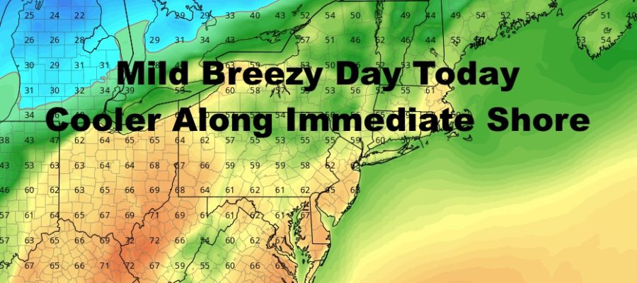
Expect more clouds than sun today with a strong, steady southerly breeze. That’ll hold temps down in the 50’s for most coastal spots and eastern Long Island, but NYC proper and interior western/central sections of Long Island, should see widespread 60-65 degree temps. Any areas that see a few extra peeks of sunshine, could creep a little higher.
REGIONAL RADAR

Overnight tonight, temps hardly drop and some areas will stick in the upper 50’s to low 60’s as lows. Showery conditions head in between 12-4am, then the main area of precip will approach tomorrow morning associated with a strong cold front.
LOCAL RADAR NEW YORK CITY

Look for gusty showers and thundershowers tomorrow morning, then a return to some showery conditions before partial clearing mid to late afternoon. Highs will be in the low to mid 60’s early, then we should begin to fall pretty fast temp-wise come sunset. After a gusty southerly fetch, expect westerlies to crank up to help with that cool down. Wind gusts may near 40mph at times.
LOCAL RADAR PHILADELPHIA


Next week starts off in the low to mid 40’s, then another system gives us near 50 temps mid-week before a return to 40 degree temps late week and into the next weekend. As of now, there remains no major snowstorms in sight for the NYC area. Again, that doesn’t mean it can’t happen, but there’s nothing on the immediate horizon.
MANY THANKS TO TROPICAL TIDBITS FOR THE USE OF MAPS
Please note that with regards to any tropical storms or hurricanes, should a storm be threatening, please consult your local National Weather Service office or your local government officials about what action you should be taking to protect life and property.