NYC Mild/Warm Spots Today With PM Showers Storms
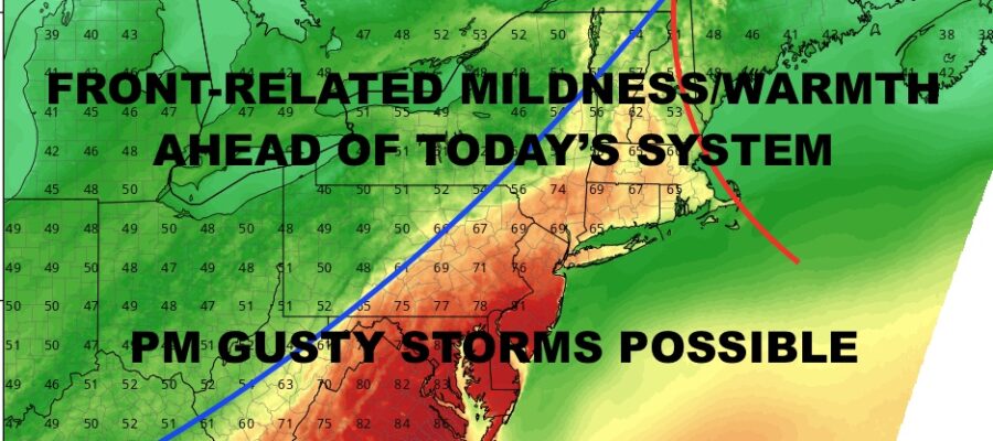
Good morning everyone. We’re starting to see some of those low clouds and fog break up, and we will be very mild to even warm in spots across the NYC Metro Area. Scattered showers and storms move through later on, but the majority of the action should be well south of us; with lower NJ, extreme SE PA, MD, DE, and VA getting the brunt of a gusty line.
SATELLITE

Clouds break up around NYC and west, low clouds and fog may stick around for an extended period. For this reason, look for 75-80 degree temps in the NYC area aside from immediate coastal areas, and may even crack 80 in a few spots; especially just west of NYC. Temps will be much cooler across LI, with a wide range of temps from mid 50’s east to mid 70’s west and north.
Again, we could see a few showers and storms, but the majority of the action slips to the south of us.
WEATHER RADAR

Sunshine returns tomorrow through Sunday, with near 60 temps and a breeze tomorrow; mid 50’s and sunshine Saturday, then near 60 temps again for a beautifully seasonable Easter Sunday.

In the long range, we continue to see the opportunity for some very mild air next workweek; with the peak of the mild air most likely Thur/Fri. As of now we will stay conservative, with low 60’s Monday and a crescendo of 70-80 degree temps Thursday and Friday.
BE SURE TO DOWNLOAD THE FREE METEOROLOGIST JOE CIOFFI WEATHER APP &
ANGRY BEN’S FREE WEATHER APP “THE ANGRY WEATHERMAN!
MANY THANKS TO TROPICAL TIDBITS & F5 WEATHER FOR THE USE OF MAPS
Please note that with regards to any severe weather, tropical storms, or hurricanes, should a storm be threatening, please consult your local National Weather Service office or your local government officials about what action you should be taking to protect life and property.