DOWNLOAD MY NEW FREE JOESTRADAMUS WEATHER APP FOR ANDROID
THE APP IS ABSOLUTELY FREE TO ALL BUT CONSIDERING SUBSCRIBING TO PATREON FOR A WEATHER EXPERIENCE FREE OF ADS, EXCLUSIVE VIDEOS FOR MEMBERS ONLY AND MUCH MORE…STARTS AT $2 A MONTH..MESSAGE ME AT ANY TIME
NYC MILD WEATHER APPROACHING COMPLICATIONS LATE NEXT WEEK
Good morning everyone. A weak disturbance is slipping to our south today and may touch off a flurry or two in the area. This represents some modification temp-wise in the area coming up, before much milder air moves in and we watch for a complicated setup late next week.
EASTERN SATELLITE

Clear skies this morning will give way to some clouds with a system taking most of its moisture well to our south. We could see a few flurries in the afternoon, but they won’t amount to much and we remain cold for one more day; highs in the upper teens to low 20’s.
REGIONAL RADAR

For our weekend, we modify quickly tomorrow and warmer air overall seems to give a pretty decent good push. Expect sun and clouds tomorrow and mid 30’s, which will feel like spring after the last couple of days we had.
Then for Sunday, we shoot up into the 40’s but those 40’s will be wide-ranging depending on if you’re along the shore, or in downtown Brooklyn/central Queens. Look for low 40’s along the shore and mid to upper 40’s in inland spots.
LOCAL RADAR NEW YORK CITY

To start the week, Monday is looking like a sure shot for low to mid 50’s (except the immediate shore) with sun and clouds, then things remain questionable for me as we go into Tuesday and Wednesday.
I want to see the timing of a weak system passing by some time on Tuesday before I make the call on how high we go. Some outlets are calling for near 60 or 60’s, but it could be a little high in my book until I see more sunshine, better timing, favorable winds involved. Is it possible? Yes, but for now I’ll remain to keep Tuesday in the 50’s.
For Wednesday I’ll do the same. I’m going to keep us in the 45-50 range unless I see anything else that makes me tingle; then things get complicated.
LOCAL RADAR PHILADELPHIA


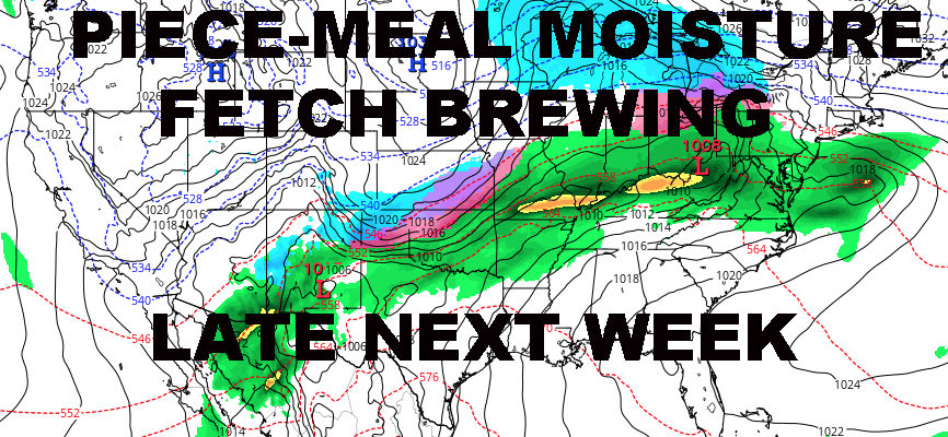
A large moisture fetch is expected from southwest to northeast across the Country, combined with several high pressure systems skirting along the northern regions and out to sea. This may wind up being a big, gloomy mess for several days starting Wednesday night.
Think of it as one giant stationary front, that sag down as a cold front, then rise back up as a warm front day to day. Depending on the timing and several overrunning opportunities, we could see a rain to mix and back to rain situation. Our temps may also fluctuate between 30’s and 50’s depending on what side of the front we are on any given day.
The fun part for me, will be watching the tail-end of this moisture fetch as everything finally pulls out. Usually on the final insult, there’s a low pressure system that’ll have to pass by somewhere as colder air returns. Will it go west and north of us again? Will it hit just right? Or will it slip south. All of these things are way to far out.
Regardless, a gloomy period is gathering and we could see 3 seasons in a span of a few days.
MANY THANKS TO TROPICAL TIDBITS FOR THE USE OF MAPS
Please note that with regards to any tropical storms or hurricanes, should a storm be threatening, please consult your local National Weather Service office or your local government officials about what action you should be taking to protect life and property.